Hiking the Great Range
Posted June 27th, 2008

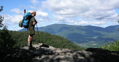
Leslee MacKenzie of Burlington, hiking on Big Slide Mountain and admiring the view of the Great Range, with Saddleback on the left. Photo by Jared Gange.
This is the seventh in a series of articles introducing the Adirondack High Peaks. The hike described this month is a rather ambitious 16-mile loop that includes two 4,000 footers on what is known as the Great Range. Previous articles have covered the ski tour to Avalanche Lake, winter hikes of Cascade and Hurricane, a ski ascent of Mount Marcy, and road biking loops out of Essex. The High Peaks Region—the rugged mountainous core of the Adirondack Park—has plenty to offer hikers, snowshoers, backcountry skiers, cyclists, paddlers, and climbers. There are more than 40 summits over 4,000 feet in the High Peaks, dozens of lakes, a couple of long-distance ski trails, and many miles of lightly traveled roads. The canoeing in the Adirondack Park is some of the best in the country. This is well known to many Vermonters, but for many others, the Adirondacks are an unknown quantity. So venture across Lake Champlain and explore!
HIKE SUMMARY
Round-trip distance: 16.3 miles
Total time: 8 to 12 hours if done as a day hike, otherwise use one of the many lean-tos or stay at JBL and take two days.
Total elevation gain: 4,200 feet
The Great Range is an east-west ridge of steep-sided peaks that runs from Keene Valley to Mount Marcy. If Haystack Mountain is included—it lies off to the south on a short spur ridge—there are eight 4,000 footers in all. The hike described in this article takes you up two of them: Saddleback Mountain and Basin Mountain. When viewed from a distance, Saddleback (4,515 feet) and Basin (4,827 feet) make a rather mild impression, at least when compared with prominent, slide-scarred peaks like Gothics, Dix, or Giant. However, the slabs on the west face of Saddleback present the most difficult bit of scrambling on a regular trail in the entire High Peaks. (Of course, there is plenty of scrambling and climbing on the many slide routes in the High Peaks, but we are talking here about hiking routes.) The high, remote, mile-long traverse between Saddleback and Basin is exhilarating. The views, of Haystack, Marcy, and especially Gothics, are outstanding.
ROUTE DESCRIPTION
Starting from the Garden, take the enjoyable walk on the Phelps Trail (yellow markers) into Department of Environmental Conservation’s Interior Outpost at 3.1 miles. This area, and higher up at Johns Brook Lodge, usually referred to as “JBL,” are the main camping/overnighting spots.
At the ranger cabin (the Outpost), pick up the Orebed Trail (blue markers) and cross Johns Brook on the little suspension bridge. Paying heed to the blue markers, stay on Orebed Trail through two intersections and make the long, and at times very steep, 1,800-foot climb to Gothics Col, 6.2 miles from the Garden. You are now on the ridgeline of the Great Range, with Gothics’ summit only 0.6 miles (a 700-foot climb) to the left. Head right on the Range Trail, also marked in blue, and reach the summit of Saddleback after 0.5 mile and 500 feet of climbing. As you ascend from the col, the view across to Gothics is so stunning that it may cause you to abandon the Saddleback-Basin traverse and climb Gothics instead! (Note: In fact, a slightly less committing option is to do Saddleback, then return to Gothics Col and climb Gothics before returning to the col once again and then retracing your steps back to the Garden, skipping Basin. This makes for “only” 15 miles.)
At any rate, from the summit of Saddleback, let the blazes lure you onward and over the precipice. Be careful and take your time on these steep slabs; this is the most difficult part of the route. Continue down into the low point of the saddle separating Basin and Saddleback. Then ascend through sparse woods, climb a bump on the ridge, and drop into a shallow col. The final climb is very steep with some scrambling and a classy little traverse (see the cover photo) just below Basin’s summit. The view from the top is panoramic, with Marcy and Haystack dominating to the west. Dix, Big Slide, Saddleback, and Lower Ausable Lake are all in view. From the summit, descend steep ledges to the junction with Shorey Short Cut, about 0.7 mile below the top. Take this trail. It climbs for a few minutes, passing a good view of Haystack, before descending steeply to the Phelps Trail. Follow this to Slant Rock Lean-to. (Slant Rock Lean-to makes a great base camp: Basin, Haystack and Marcy are all relatively close.) From here it is simply a matter of following the Phelps Trail (red markers for 1.7 miles, then yellow) all the way back to the Garden, a distance of 6.8 miles; Bushnell Falls Lean-to and the crossing of Johns Brook is 1.8 miles distant, and Johns Brook Lodge is 3.3 miles.
DRIVING DIRECTIONS
When approaching from the Burlington area, take the Charlotte ferry to Essex, NY. Head left on NY22 before turning right almost immediately (100 yards), to stay on NY22 south. Continue on NY22 to the tiny hamlet of Wadhams, at 9 miles from Essex. Here, just past Merrick’s Bakery (now known as the Dogwood Bread Company), make a sharp right turn, and follow County Road 8 to Elizabethtown and US Route 9, at about 16 miles. Head left and proceed straight through E-town (gas, groceries) to where NY Route 9N turns right. Follow this up a prolonged climb before descending into Keene Valley and a T-intersection with NY73. Turn left and continue 3 miles south to the village of Keene Valley, where there are restaurants, a grocery store, and an excellent outdoor outfitter, The Mountaineer. In the center of Keene Valley, turn right on Adirondack Street and drive 1.6 miles to the trailhead at the end of the road. This spot is known as the Garden. Unfortunately, parking is very limited here, and you may have to use the overflow parking at Marcy Field, located just off NY73, about a mile south of the T-intersection of Route 9N and NY73 (mentioned above), before you get to Keene Valley. A nominal parking fee is charged.
If you choose not to use the ferry, drive south through Vergennes to Route 17, cross the Crown Point Bridge, and head north through Westport and on to Elizabethtown. Then continue as above.