Easy Hikes Around Lake Champlain | You Don’t Have to be a 46er to Master These Treks

Before 1609, when the great explorer Samuel de Champlain named Lake Champlain for himself, the Abenaki called it “Petonbowk,” which means “waters that lie between,” an apt name for this 120-mile-long body of water that lies between two magnificent mountain ranges, the Green Mountains in Vermont and the Adirondacks in New York.
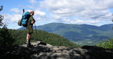
Both the Green Mountains and the Adirondacks are hiking meccas, where avid backcountry trekkers can push themselves on epic multiday journeys, and where aerobically advanced men and women follow footpaths for a dozen miles in a day. In the Adirondacks, it’s easy to get an inferiority complex if you’re not a “46er”, i.e., someone who has climbed all 46 peaks over 4,000 feet. Ditto in Vermont, if you haven’t hiked the entire Long Trail.
But not everyone has the ability or the time for marathons in the mountains. Here are six family-friendly routes with big views of Lake Champlain. They are located along the full length of the lake and on both sides of it, offering a different perspective with each climb.
ADIRONDACK SIDE
Lyon Mountain
Nearest town: Chazy Lake, N.Y.
Distance: 6.4 miles, out and back
High point: 3,829 feet
Vertical climb: 1,904 feet
Hiking time: 4 hours
Dog friendly: Yes
Trailhead: N44 43.424′ / W73 50.519′
The hike up Lyon Mountain starts out fairly flat, as it winds through a classic mixed northern forest. It turns steeper for the second half of the hike, climbing up an old washout, which is the most interesting part of the hike. A variety of wildflowers grow on this lengthy opening, and you get constant views to the east. A 35-foot fire tower and an open rocky summit await you at the top.
Lyon Mountain is only 171 feet short of making the 4,000-footer list. It is a monadnock—a peak that stands alone—about 30 miles west of Plattsburgh, on the southwestern shore of Chazy Lake. From 1870 to 1967, iron ore was mined from the mountain. Considered some of the finest iron ore in the world, it was used in structures such as the Golden Gate Bridge in San Francisco.
In 2005 the state of New York purchased 20,000 acres of land in the northern Adirondacks, including Lyon Mountain, from the Nature Conservancy for $9.8 million, which was about the time restoration work on the fire tower began. The current trail opened in 2009. Unlike many trails in the Adirondacks, it has modern-day switchbacks and a moderate incline until it meets the old trail.
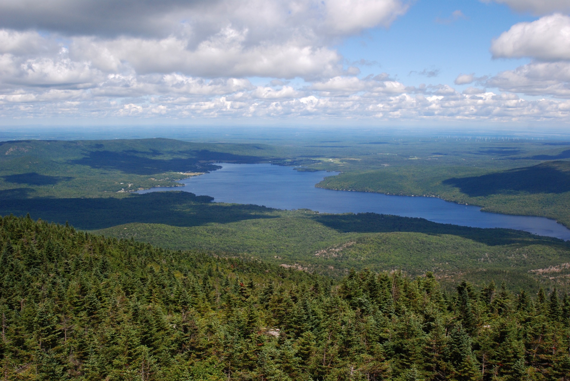
The panorama from atop Lyon Mountain is the king of views in the northern Adirondacks. You can see the highest peaks in both New York and Vermont across Lake Champlain from atop its fire tower, as well as Montreal, Quebec.

2. Cascade Mountain
Nearest town: Lake Placid, N.Y.
Distance: 4.2 miles, out and back
High point: 4,098 feet
Vertical climb: 1,899 feet
Hiking time: 4 hours
Dog friendly: Yes. Dogs must be on a leash.
Trailhead: N44 13.136′ / W73 53.254′
With a reputation as the easiest of the 4,000-footers in the Adirondacks, this is a popular route, so you’ll likely have company on the trail. Arrive early to insure a parking spot in one of the three turnouts by the trailhead. Save this one for a nice day, as there is a lot of open rock on the upper hike that gets slick when wet.
The eroded path has lots of step-like rocks and roots. Numerous water bars and well-placed stones also help the lower part of the climb. The path crosses a stream that flows down a pretty cascade, traverses a mud hole on stepping stones, and then gets rockier as it heads higher and deeper into the forest.
At 1.7 miles, the trail breaks out onto an open rock. Mount Marcy, the highest of the famous Adirondack High Peaks, looms large to the west, and there is a great view of the ski jumps and Lake Placid to the north.
When the trail leaves the trees for good, it’s a steep climb to the expansive bald summit, where you’ll find many perches for a private picnic even on a busy day. You can see the fire tower on Hurricane Mountain to the east, Memorial Highway snaking up Whiteface to the north, Lake Placid village and lake to the northwest, and a mesmerizing number of 4,000-footers to the south including the famous Great Range (Gothics, Armstrong, Upper Wolfjaw, and Lower Wolfjaw). Lake Champlain and the main ridge of the Green Mountains take up the eastern panorama.
3. Poke-O-Moonshine
Nearest town: Keeseville, N.Y.
Distance: 2.4 miles, out and back
High point: 2,180 feet
Vertical climb: 1,262 feet
Hiking time: 2.5 hours
Dog friendly: Yes. Dogs must be on leash.
Trailhead: N44 24.202′ / W73 30.148′
Poke-O-Moonshine is an anglicized version of two Algonquin words, “pohqui,” which means “broken,” and “moosie,” which means “smooth.” It is an apt description of the well-used rock-strewn trail to the top of this famous cliff, a wall of granite gneiss that rises 1,000 feet from the valley floor.
The hike begins at a closed state campground. It’s a steady uphill climb most of the way along an interpretive trail. Numbers on stakes point out various examples of natural history, geology, trail work, and flora. Brochures are available at the sign-in box at the trailhead.
The trail passes several large glacial erratics. White wood asters bloom at the foot of maples, beech, and birches, the dominant trees in the forest mix. A number of stone water bars and other well-placed rocks help keep the trail in shape.
At 0.8 mile, the trail comes to the chimney and foundation of the old fire-watcher’s cabin. It flattens after the cabin, passing a lookout on your left, where you can see Whiteface Mountain to the northwest. The narrow trail is smooth and easygoing, basically along the edge of a cliff, but with a row of trees as a buffer. Clintonia and bunchberries bloom along the edges of the trail, signaling your elevation gain.
The fire tower atop Poke-O-Moonshine is a National Historic Landmark. It is not particularly high and the cabin is likely locked, but the view is terrific nonetheless. Lake Champlain takes up the entire eastern panorama, with Camel’s Hump the dominant mountain beyond in the Green Mountains. The Adirondack High Peaks are equally spectacular to the northwest.
GREEN MOUNTAIN SIDE
4. Mount Abraham via the Long Trail
Nearest town: Warren
Distance: 5.2 miles, out and back
High point: 4,006 feet
Vertical climb: 1,700 feet
Hiking time: 4.5 hours
Dog friendly: Yes. Dogs must be on leash in the alpine zone.
Trailhead: N44 05.733’ / W72 55.734’
Mount Abraham is the lowest of the five 4,000-foot peaks in Vermont. Likewise, it is the fifth highest point in the state. It is a popular hike and relatively short for the big reward at the top, a view across Lake Champlain into New York to the west; New Hampshire to the east; and a significant portion of the Vermont’s Green Mountains to the north and south.
From the top of Lincoln Gap, the Long Trail-North meanders through the woods on the approach to Mount Abraham. The trailhead is relatively high (2,531 feet), already in the boreal zone. The trail winds up through a typical boreal forest, primarily spruce, balsam, and birch, with glimpses to the west through the trees. At 0.4 mile, the trail starts to climb. It also becomes more rocky and rooted but nothing extreme. Periodic stone steps aid your footing.
After passing the junction with the Battell Trail, you come to Battell Shelter at 1.8 miles. Both the trail and the shelter are named for Joseph Battell, a conservationist and former owner of the Bread Loaf Inn, who cut a trail to Mount Ellen in 1901. Above Battell Shelter the trees get noticeably shorter, and the trail turns to slab. Just below the summit, it comes to a large white quartzite rock that rests beside the trail like a giant egg.
The alpine zone on Mount Abraham is the smallest of the three peaks, about the size of a large living room. An array of fragile alpine plants survives there despite an abbreviated two-month growing season. The grass on the summit is not common grass, but rare Bigelow’s Sedge. Tread only on the rocks as you take in the 360-degree view.
5. MOUNT INDEPENDENCE
Nearest town: Orwell
Distance: 2.9 miles, loop
High point: 306 feet
Vertical climb: 200 feet
Hiking time: 2.5 hours
Dog friendly: Yes. Dogs should be on leash.
Trailhead: N43 49.092’ / W73 23.011’
Mount Independence was named by the soldiers who were stationed there in 1776 when they received word of the signing of the Declaration of Independence. It’s not really a mountain, but a rocky bluff at the end of a peninsula located by the narrow southern part of Lake Champlain across from Fort Ticonderoga. Hiking through this active archeological site is a step back in time.
The best loop on the Mount Independence trail system follows the shoreline and returns through the center of the peninsula along the highest promontory. It starts at the Visitors’ Center and follows a former military road. Today, the road is grassy picnic area surrounded by dense forest and an incredible display of wild flowers.
The trail heads down to the lake, soon passing a murky pool at the base of the old parapet, then the site of a quarry that dates back to the 1750s. Stones from this quarry were hauled over the ice to build Fort Ticonderoga.
At 2.2 miles, the trail descends a rocky perch, where masts were lowered onto ships. A little farther down the lakeshore, the trail comes to a broad rock slab, the former site of a floating bridge that connected Mount Independence to Fort Ticonderoga.
The next field is the site of a former shore battery where thirty cannons greeted the British when they tried to approach in 1776. The history lesson continues as you trek across the middle of the peninsula, passing the Horseshoe Battery and another striking view of the lake. After passing a half-dozen more points of interest, the time machine delivers you back to the Visitors’ Center where you started.
6. MOUNT PHILO
Nearest town: Charlotte
Distance: 2 miles, out and back
High point: 980 feet
Vertical climb: 650 feet
Hiking time: 2 hours
Dog friendly: Yes. Dogs must be on leash and have a current rabies vaccine tag.
Trailhead: N44 16.685’ / W73 13.391’
Mount Philo is the centerpiece of Mount Philo State Park, Vermont’s oldest state park. The park was established in 1924 when Frances Humphreys gave 150 acres to the state. The hiking trails were added 72 years later, in 1996, by the Vermont Youth Conservation Corps. Philo is a midget by normal mountain standards, but it towers over the middle of the Lake Champlain Valley, offering exceptional views of the lake and the Adirondacks beyond.
The Mount Philo Trail enters the woods on the left side of the park road, which also goes to the summit. Wildflowers line the path. There are many maples in the hardwood mix, which make this hike a local favorite during fall foliage season. The trail climbs steadily to House Rock, a large boulder that is hollowed out underneath, like an overhang. The route turns left around House Rock traversing to the northeast passing a couple of large boulders as it ascends.
At 0.4 mile, the trail crosses the auto road then climbs to the junction with a rocky spur trail to Devil’s Chair. The intersection is notable itself for the cleft in a rock that is fun to squeeze inside.
From here, the path continues uphill, swinging right at the top of another distinct boulder, where there is an obstructed view through cedar trees of Lake Champlain and the farmland below. After a rough steep section, the pitch eases. The trail bends away from the perch and climbs another rise to the summit picnic area atop an open cliff. On a clear day, you can see as far as Whiteface Mountain near Lake Placid, N.Y.
MORE INFO
Adirondack Mountain Club: (518) 668-4447; www.adk.org
Mount Abraham: Green Mountain Club; 244-7037; www.greenmountainclub.org
Mount Independence: State of Vermont, Division for Historic Preservation, 759-2412; www.historicvermont.org/mountindependence
Mount Philo: Vermont Department of Forests, Parks and Recreation, 425-2390 (seasonal) or 786-0060 (off-season), www.vtstateparks.com