
Seven High Country Hikes
While the rest of the world is leaf peeping in the valleys, get your last look at the high country before the snow falls on these ridgeline hikes.
Vermont has its peaks and valleys and, come October, you can bet both will be packed. How to escape the crowds? Head up and over.
This fall, before the snowpack builds, escape the crowds at the usual scenic outlooks and travel the trails that traverse the Green Mountains. Many start at ski areas where you can save your legs by taking a lift to the top (provided you’ve got a ski pass). These hikes all include trails marked on maps published by the Green Mountain Club.
On some routes, it’s possible to include an overnight in lean-tos or cabins (see A Cabin for Any Season). All cabins and shelters listed on the Long Trail are filled in a first-come, first-served basis, so bring a tent in case you find them full.
Mt. Pisgah North Trail **
(Westmore, 4.4 miles round trip)
Get some perspective on Vermont’s Northeast Kingdom with this hike above Lake Willoughby, Vermont’s deepest and most dramatic lake. From the parking area near the southern end of the lake on Route 5a, the trail follows old logging roads and gains elevation until it intersects with smaller spur trails that lead to a north and a west lookout. There, overlooking the fjord-like lake, Mt. Hor rises 1,400 feet. Nearby, you’ll see Wheeler Mountain, Lake Memphremagog, Owl’s Head and Bear Mountain. Beyond, you can pick out a string of summits from Camel’s Hump to Jay Peak, Burke and a few summits in Quebec. Take in the view from both of these lookouts before continuing to the summit of Mount Pisgah.
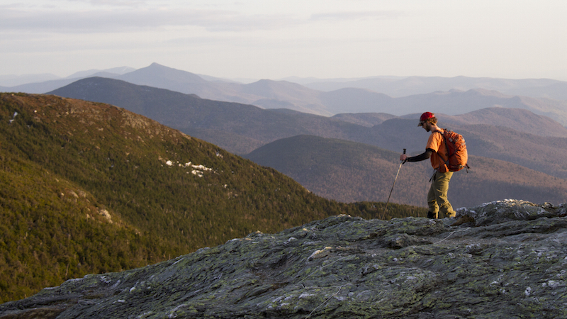
Mount Mansfield’s Ridgeline ***
(Stowe, 2-10 miles one-way)
One of the most rugged environments in the state is also the most accessible. Part of the Long Trail, the alpine footpath along the roof of Vermont is accessible from all directions and especially easy if you take Stowe’s gondola or drive up the Toll Toad. For a longer hike with more exposure, start on the western side from Underhill State Park on the 1.4-mile Frost Trail or the 1.4-mile Sunset Ridge Trail. The Frost Trail emerges from a thick forest to intersect with the Long Trail at the massive Forehead while the Sunset Ridge Trail ascends to the 4,395-foot Chin to the north. From Chin to Forehead is just over a mile. You can also choose to hike from the north by the 1.5-mile Hellbrook Trail, which ascends from Smuggler’s Notch. It’s a challenging route with steep ledges and ladders. For an extended hike, link up with the Long Trail and head south to Taylor Lodge, about 10 miles later in Nebraska Valley.
Mad River Glen to Sugarbush, ***
(Waitsfield, 5.8 miles one-way)
You can start this hike by taking Mad River Glen’s historic single chair to the Stark’s Nest warming hut at the top of the ski area or you can hike south from the parking area on Route 17 at the top of the Appalachian Gap (adding 3.1 miles). After passing over the summit of General Stark Mountain (3,662 feet), you’ll find an opportunity for an overnight at the Glen Ellen shelter, just a mile down the trail. The elevation rises gradually to the summit of the second ski area, and the ridge’s highest point, Sugarbush’s Mount Ellen. At 4,083 feet it’s the third-tallest mountain in Vermont and its northern exposure gives excellent views of Camel’s Hump, the Worcester Range and Mount Mansfield. After passing over two small, craggy peaks look down the eastern flank at terrain that’s home to some of the area’s legendary glade skiing. The conclusion is a short distance later at Lincoln Peak, with views down to Sugarbush’s Lincoln Peak Village, Mount Abraham (to the south) and the Champlain Valley to the west. Descend on the hiking trails to the Super Bravo Lift where you can catch a ride to the bottom and the Lincoln Peak Village.
The Breadloaf Wilderness ****
(Hancock, 10.4 miles roundtrip)
The largest of the designated wilderness areas in the Green Mountain National Forest makes for a long day hike or a great overnight. Start your day at the top of Middlebury Gap near the Middlebury College Snow Bowl. After starting out northbound on the Long Trail, explore the Silent Cliff and nearby cave via a .4-mile side trail that cuts to the east just .4 miles after the start. While hiking through one of Vermont’s most pristine forests, you’ll summit Burnt Hill (3,040’) and Kirby Peak (3,140’) before reaching the Skyline Lodge, a log cabin built in 1987. Its broad porch and bunks for 14 will be a welcome resting spot while you overlook the Skylight Pond in the evening.
Pico and Killington Link ***
(Killington, 5.4 miles roundtrip)
This hike connects Pico and Killington along a ridge with sweeping views. Your adventure starts with a quick ride up Killington’s K1 gondola to the summit of the second tallest mountain in Vermont at 4,235 feet. From Killington, you’ll be able to see north to Mount Mansfield and south to Ascutney, Okemo and even Stratton. Travel north on the Long Trail through alpine forests and past the Bucklin Trail, which descends to the west and Snowdon Peak (3,592’), then along a ridgeline to an intersection with Sherburne Pass Trail called “Jungle Junction.” Bear right for a half-mile before reaching Pico Peak (3,957’). When you’re rested, retrace your steps to Killington for an easy descent via the K1 gondola.
West Ridge Trail to Goddard Shelter *****
(Bennington, 9.7 miles one-way)
If you’re looking for an ambitious ridgeline hike, perhaps with an overnight at a cabin, head for this trail that starts close to downtown Bennington. From the parking area on Harbour Road climb 1.9 miles on the Bear Wallow Trail to the 2,857-foot summit of Bald Mountain. You’ll have views of the Bennington Battlefield Monument, Mount Anthony and the surrounding area. From Bald Mountain, the trail passes over two smaller peaks before turning sharply east to the intersection with the Long Trail/Appalachian Trail at the Goddard Shelter. There you can lay out a sleeping bag for the night. Cap the hike at the summit of Glastenbury Mountain (3,748’) and scale the ladder to the firetower for views of Stratton Mountain and the northern Greens.
 Stratton Mountain **
(Arlington, 7.6 miles roundtrip)
In 1909, a man named James Taylor climbed to the summit of Stratton Mountain, the highest peak in southern Vermont. What he saw gave him the idea for the Long Trail, stretching the length of the Green Mountains. A few years later, as he was at Stratton Mountain working on the Long Trail, forester Benton MacKaye took it up a notch and conceived of the 2,160-mile-long Appalachian Trail. Today, the 3,199-foot peak is a site on both the Long Trail, which runs the length of Vermont, and the Appalachian Trail, which stretches from Georgia to Maine. For an easy hike, ride Stratton’s gondola to the summit of the ski area and follow signs for Mike’s Way and the trail that leads to the firetower (1.4 miles roundtrip). But for a wilder route, start from the parking area on the Kelly Stand Road in Arlington. The trail ascends gradually through mixed forest before a series of switchbacks. Openings on the trail give southern views to Somerset Reservoir. At the summit, climb the 70-foot firetower built by the Civilian Conservation Corps in 1934. From a lofty perch you’ll have a view similar to what Benton MacKaye must have seen, all the way to New York’s Taconic Mountains and the White Mountains of New Hampshire.
Pingback: Mountain Top View Vermont – Your Next Trip Destinations