
Your Guide to Backcountry Skiing in Vermont
Sure, there’s Brandon Gap. But around Vermont new and up-and-coming backcountry zones are giving more skiers the chance to find fresh tracks.
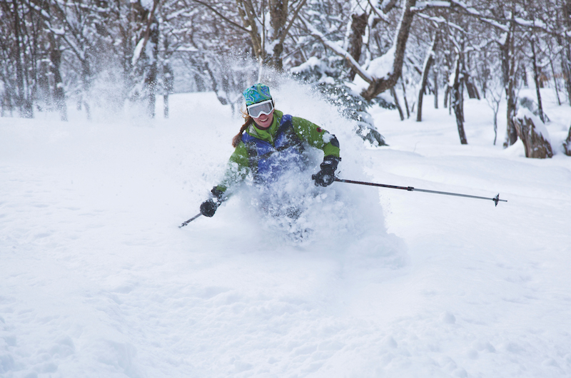
It was freezing. The snow was so light it scattered like glitter with each push of our skis.
We were climbing, my friend and I, ever upward. Stands of beech and maple opened up from time to time to give views of the ice flows on Mt. Pisgah. After a short stretch on a groomed Nordic trail, we came to another skin track. Here, the forest changed entirely. Open maple glades soon gave way to a dark crown of fir and spruce as we wound our way up a steep skin track to the 2,648-foot summit of Mt. Hor. In the cold mountain light the landscape was almost blue.
As snow swirled across the cliff bands, we found ourselves alone. Dropping in to the first sanctioned ski glades cut on state-owned land in Vermont, we found steep spruce and birch glades blanketed with untracked powder that reached our thighs.
Though skiing at Lake Willoughby State Forest is magical, it’s not the only place in Vermont where you can find solitude and untracked snow far from the beaten tracks of ski resorts.
When Vermont journalist David Goodman first published his definitive guidebook Best Backcountry Skiing in the Northeast: 50 Classic Ski Tours, 30 years ago, backcountry skiing was a bit of a niche sport. As he prepares to publish the fourth edition of the book in the fall of 2020, he calls the recent boom in new skiing in Vermont since 2010 “an explosion.”
“I think the backcountry ski scene [in Vermont] is probably more vibrant and thriving now than it’s been since backcountry skiing had its heydey in the 1930s and 1940s, before chairlifts went up,” says Goodman. “We’ve come full circle, back to that sense of excitement and exploration and development of new trails. I think we are riding the front edge of a wave here.”
Since 2016, five sanctioned glade-cutting projects have been established on federal and state lands around Vermont. Since the Rochester-Randolph Area Sports Trails Alliance formed in 2013 and became the Catamount Trail Association’s first chapter, five other chapters have cropped up across the state. Some, like the Dutch Hill Alliance of Skiers and Riders (DHASH) and Northeast Kingdom Backcountry Coalition have developed new glades. Others like the Mad River Valley and Grateful Shreds Backcountry Coalitions are still building support to launch projects.
What’s happening around Vermont is a backcountry revolution of sorts. “In Vermont, we have communities that have made a commitment to developing backcountry ski zones where the sport can bring people together,” says Matt Williams, executive director of the Catamount Trail Association.
Willams, who grew up skiing out of his Sharon backyard on a three-pin telemark setup, adds: “Most places you go in the world, backcountry skiers are reluctant to share their favorite stashes.”
However, if solitude is what you’re after, he says, there will always be untracked powder in the depths of the Green Mountains—skiing in natural glades known only to locals and accessed by landowner permission or in rare stands of old growth and moose browse on public lands.
“The skiing here in Vermont is world-class, but it’s not readily apparent. It takes some work to find the hidden lines, and you could spend a lifetime exploring our winter landscape.”
Here are a few places to start, from north to south.
Willoughby State Forest: The First Sanctioned Glading on Vermont State Land
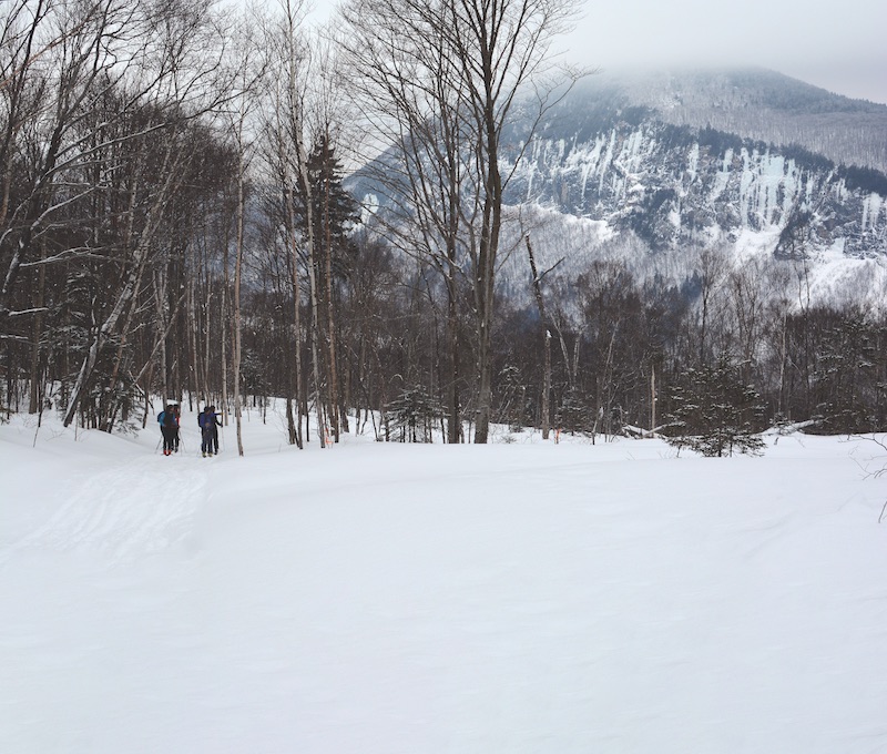
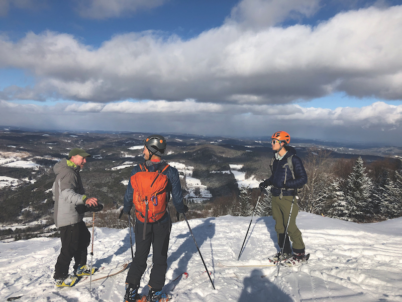
Drive to Lake Willoughby in the dead of winter and you’ll find the mountains that form this 1,500-foot-deep granite cleft hold deep snow, varied glades and exciting terrain. Willoughby State Forest is home to the first sanctioned ski glades created on Vermont state land—cut in 2016. Here, you’ll find low-angle beech and birch glades on east-facing Bartlett Mountain and serious steeps (the steepest in NEKBC’s managed zones) with well-spaced fir and spruce from the summit cone of Mt. Hor. The two areas are accessed via the same skin track, which leaves from a parking lot off of Route 5A at the south end of Lake Willoughby to meet a 12-kilometer network of groomed Nordic ski trails, with stunning views of Mt. Pisgah through the trees. Both peaks—Bartlett rounded and gentle, and Mt. Hor rocky and pointed—are easy to lap and close together, making this the perfect place to head with a group or to ski hard in the morning and hit gentler terrain in the afternoon. “It’s the place we suggest if you want a first taste of the Northeast Kingdom backcountry,” says NEKBC President Maria Young.
Closest Town: Westmore Managed by: Northeast Kingdom Backcountry Coalition (NEKBC) Vertical Drop: 640 feet on Bartlett Mountain; 820 feet on Mt. Hor Difficulty: Beginner to Expert; Après: The Gap Pub & Grill for fried pickles, real poutine and drafts from Saint J Brewery in St. Johnsbury; Stay: For a drive-in backcountry cabin experience, book a night at the Green Mountain Club’s Wheeler Pond Camps ($75) in Barton and hunker down by the big woodstove or ski across Wheeler Pond in the morning. You’ll have the whole basin to yourself. For an affordable, heated room, book a bunk in the 16-person bunkroom at Northwoods Stewardship Center ($150 per night for groups of up to five, $25 per night per person thereafter). Maps and Intel: nekbc.org
Moose Haven and Kirby Ridge: Backwoods Powder Troves
Where the glades at Willoughby State Forest are open, accessed by groomed trails and well-mapped, the new lines cut on Kirby Ridge in Kirby and in MooseHaven Forest in East Haven, 15 miles away, are anything but. Four-wheel drive is a must to reach the trailhead parking for both areas, which is on private land. At this point, NEKBC recommends only skiing Kirby Ridge and Moose Haven with someone who is familiar with the zone, or joining NEKBC for one of their next work days at the
sites to learn the ins and outs of how to navigate them.
At MooseHaven, NEKBC cut two new intermediate-advanced lines from the top of a long ridge, with 1,000 feet of gladed skiing from top to bottom. The lines—No Show and Under the Radar—are a nod to the East Haven Mountain Radar Base, a Cold War-era radar tower atop East Haven Mountain—the next ridge over.
“These are beautiful woods with big old birch trees and an open understory shaped by browsing moose,” says Young. No dogs are allowed here, and the lines have a wild and rambling feel. This was a deliberate choice by NEKBC, the conservation-minded landowner and forester Dave Senio. A sign marks the parking lot this year, off of Young’s Road.
If you want to ski Kirby Ridge, Young highly recommends attending an NEKBC work day or finding a willing local to show you. “This is a small but steep zone with plenty of little rocks and hucks that is west-facing in a hardwood forest of beech, ash and birch,” says Young. Maps and signage are forthcoming. “This is big terrain.”
Closest Town: East Haven (Moose Haven); Kirby (Kirby Ridge); Managed by: Northeast Kingdom Backcountry Coalition (NEKBC) Vertical Drop: 1,000 feet on Moose Haven; 600 feet on Kirby Ridge; Difficulty: Intermediate to Expert; Après: The Hub on the Hill or Publick House in East Burke; Stay: The Essex House at Island Pond ($75-$149 per night). Maps and Intel: nekbc.org
The Bolton Backcountry: A Backcountry Ski Area
On the leeward, northeast facing faces of the high ridges around Bolton Valley Resort, you’ll find light, cold powder from lake effect storms over Lake Champlain in plentiful piles that stick around even after wind or warm weather.
Here, in addition to Bolton Valley Resort’s groomed ski trails, there’s a 100 km network of narrow old-school, CCC-style backcountry trails and glades. Bolton’s backcountry offers everything from low-angle skiing through mellow stands of old-growth white and yellow birch to steep balsam fir glades and narrow chutes through cliff bands.
The resort has become something of a Ground Zero for backcountry skiing in Vermont, with backcountry lessons and state-of-the-art alpine touring and splitboard rental gear available at the Nordic Center, a new warming hut situated atop some of the most popular ski runs, as well as two backcountry huts with woodstoves that you can book for overnight stays through the Green Mountain Club: Bolton Cabin and Bryant Camp.
This year, the resort is offering a backcountry access ticket for $17 (a Nordic & Backcountry season’s pass is $179 and $129 for Catamount Trail Association members and includes three one-ride lift tickets that can be shared with a friend). A Nordic/Backcountry/Uphill Pass or ticket is now required at all times on Bolton’s Nordic, backcountry and designated uphill routes, whether or not lifts are running at the resort.
The Catamount Trail runs along the ridgeline from Bolton Valley to Nebraska Valley in Stowe. There, experienced skiers looking for a five or six-hour meandering point-to-point ski tour can skin and ski the 9.4 miles from Bolton Valley’s Nordic Center (the trailhead for its managed backcountry zone) to climb 1,300 feet and descend 2,300 feet through open forest with views of the Worcester Range and Little River Valley along the way.
The Catamount Trail Association offers a shuttle service back to Bolton Valley on Saturdays in January and February (see catamounttrail.org for the schedule), but you can also continue on to Trapp Family Lodge for a night at the resort.
For another rolling and meandering tour with opportunities to lap steeper glades along the way, pay $15 for a single lift ride up Bolton’s Vista Quad to access the six-mile Woodward Trail. This trail, cut in 1972 by Vermont ski pioneer Gardiner Lane and his infamous crew of “Old Goat” trailblazers, winds from Bolton Valley to Little River Road in Waterbury. The route features rolling terrain but rewards skiers with a gentle 2,500-foot descent to Waterbury Reservoir, the former site of the town of Woodward, Vt. See David Goodman’s guidebook Best Backcountry Skiing in the Northeast for more information about the trail’s history and terrain.
Closest Town: Bolton; Opened: 1920s; Managed by: Bolton Valley Ski Area and Catamount Trail Association; Vertical Drop: 1,700 feet with 1,500 acres of ski touring; Difficulty: Novice to Expert; Après: Grab one of the local beers on draught and a wood-fired pizza at the James Moore Tavern in Bolton’s retro lodge; Stay: The Inn at Bolton Valley (boltonvalley.com) or Trapp Family Lodge in Stowe; Maps and Intel: For a detailed map of the area and ski lines as well as trails, head to boltonvalley.com
Brandon Gap: The Brainchild
Since 2016, when four backcountry ski zones were created by the Rochester-Randolph Area Sports Trails Alliance (RASTA) in a pioneering partnership with the Green Mountain National Forest, Brandon Gap has become a legendary backcountry zone.
There are now about 22 lines through a mix of birch glades and snow-laden conifers accessible right from two parking areas on Route 73 (Brandon Gap). While weekends tend to get busy with folks driving from as far as Boston to ski and ride the glades, it’s the perfect place to grab quick laps before or after work or to spend an entire day exploring its varied zones.
The terrain ranges from moderate to advanced, and the braided network of ski lines is designed so that even if you show up on a busy Saturday, you’ll find quiet on the skin track and in the trees.
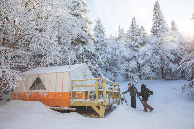
From the Bear Brook Bowl Trailhead you’ll find two zones: No Name and Bear Brook Bowl. Bear Brook’s skin track meets The Chittenden Brook Trail, which leads ultimately to Chittenden Brook Hut (a two-and-a-half-mile tour). If you plan ahead, you can score an overnight at Chittenden Brook Hut, an insulated, thermostat-regulated, remote cabin just four miles down the road, part of the Vermont Huts Association’s growing network—though it’s a two-mile ski in to the cabin, which is not near the gladed zones.
With 1,300 feet of vertical drop and terrain features like boulders and cliff bands to huck, the six lines in Bear Brook Bowl are challenging. In contrast, No Name offers 1,100 feet of vertical, braided moderate lines including a “new line in the middle that is nice and mellow compared with the steeper stuff at Brandon Gap, with a consistent pitch the whole way down,” says RASTA President Angus McCusker, adding, “This zone is perfect for a lunch break or early morning tour—it’s designed so that you can peel off halfway up and ski quick laps.”
From the Brandon Gap Long Trail Parking Lot, you’ll find Goshen Mountain Backcountry Area and Sunrise Bowl, both accessed via The Long Trail. The Summit of Goshen Mountain is open, with acres upon acres of high elevation, skiable meadows which offer views of the Green Mountain spine looking North and even the White Mountains to the East. Sunrise Bowl offers 500 feet of vertical drop on easier, more open terrain, while the Goshen Mountain Zone features five lines ranging from moderate to expert terrain as you move from skier’s right to left.
Pro tip: on a powder day or weekend, RASTA recommends parking at the park & ride in Rochester, or at Graves Church in Forest Dale, then carpooling to the trailhead parking.
Closest Towns: Brandon and Rochester; Opened: 2016 Managed by: RASTA; Vertical Drop: 16,000 vertical feet of skiing (total); Difficulty: Intermediate to Expert; Après: Grab a beer at Red Clover Brewing Co. in Brandon or morning French pastries at Café Provence or head to cozy Sandy’s Books and Bakery in Rochester. Stay: Chittenden Brook Hut at Chittenden Campground ($140 per night; vermonthuts.org); In the Works: RASTA has received preliminary approval from the U.S. Forest Service to establish gladed skiing on the two peaks (Corporation Mountain and Round Mountain) that form Chittenden Brook Bowl, which faces the Chittenden Brook Hut and is a two-mile ski via the Long Trail from the top of Bear Brook Bowl at Brandon Gap. “It’s likely that project will proceed next summer or the summer after,” says RASTA president Angus McCusker. Maps and Intel: For a detailed map of the area and ski lines, head to rastavt.org.
Braintree Mountain Forest: The Secret Stash
If you want to find solace on a long tour in the woods that culminates in untouched powder runs, Braintree Mountain may be for you. With an hour-long approach to the heart of the Braintree range, it’s the perfect place for a set of fat, fish-scale backcountry skis and three-pin bindings. “It offers a wonderful opportunity to ski some historic old Vermont woods and roads,” says RASTA volunteer and lifelong local Zac Freeman. “It’s just a stunning network of cross country and Nordic touring trails that lead to some great ski runs.”
Braintree Mountain Forest spans 1,547 acres of undeveloped land off of Riford Brook Road in the town of Braintree, and encompasses four peaks: Round Top, Twin Peaks, Skidoo and Braintree Mountain, known to locals as “30-30.”
Head to Twin Peaks for two tighter tree lines that hug a flowing, continuous fall line. At Skiddoo, you’ll find eight dreamy ski lines off of the top of the ridge. Ski laps from the Bell Gates Cabin, a day-use only warming hut at the base of the bowl. “At the top of Skiddoo, you’ll find these big open moose meadows, like at the top of Goshen Mountain,” says Angus McCusker. “They never logged that high, so the forest is naturally open and relatively untouched. The skiing gets tighter as you descend into the lines cut by volunteers.”
Closest Town: Braintree; Opened: 2014; Managed by: RASTA; Vertical Drop: 1,500 feet with 1,547 acres of touring; Difficulty: Novice to Intermediate; Après: Grab a beer at Bent Hill Brewery in Braintree and catch live music from local bands on weekends in the Upstairs Gallery at Chandler Music Hall in downtown Randolph; Stay: Chittenden Brook Hut; In the Works: This spring, look out for the new OutdoorHub, RASTA’s timberfame base in downtown Randolph, with a gear shop, 3D maps of the mountain biking and backcountry ski trails in the area, a bar, coin-operated showers and garden with food trucks. Maps and Intel: For a detailed map of the area and ski lines as well as trails, head to rastavt.org.
Ascutney: The Sprawling Playground
At 3,130 feet high, Mount Ascutney is a monadnock—a singular peak that rises from the valley above the town of Brownsville. Since the 469-acre ski area shuttered in 2010, a band of local volunteers called Ascutney Outdoors has revitalized the old trails—trimming back vegetation and re-establishing 50 acres of hardwood and red pine glades between the steep, winding former ski trails (think a smaller Mad River Glen) on the upper two thirds of the mountain. Starting Jan. 18, backcountry skiers will be able to hitch a 1,800-foot ride on the new Dopplemeyer T-Bar, which restores lift service to ten easy-to-moderate trails on the lower mountain. Even with a boost, you’ll still have a good skin or snowshoe to reach the toughest terrain. This is the perfect place to gently introduce a friend or kids to backcountry skiing. In the summer, the mountain features 50 miles of world-renowned cross-country mountain bike and hiking trails managed by a local Vermont Mountain Bike Association chapter, Sports Trails of the Ascutney Basin.
Closest Town: Brownsville; Opened: 2015 Managed by: Ascutney Outdoors; Vertical Drop: 1,443 feet; Difficulty: Novice to expert; Après: Brownsville Butcher and Pantry Stay: Free off-season in the lean-tos at Mount Ascutney State Park; In the Works: No new glades, but more work to restore the existing ski trails; Maps and Intel: For trail information, head to the Ascutney Outdoors Center and Main Trailhead at the base of the former ski area. ascutneyoutdoors.org
Dutch Hill: The Little Stowe
For some old-fashioned tree skiing on mostly moderately pitched terrain, head to 83-acre Dutch Hill, in Readsboro. Dutch Hill was operated as a ski area until 1985, and DHASH president Bill Beattie, who learned to ski there, says it’s the perfect place to ski fast laps or cut your teeth on mellow, wide-cut glades and mostly-clear former ski trails in the backcountry. Six lines have been completed and the intent is to submit plans for 12 more to the U.S. Forest Service, which manages this land in the southern half of the Green Mountain National Forest.
“We used to be known as The Little Stowe for our steep terrain. We’ve got plenty that’s mellow, but there are a few expert lines through some cliff bands that are pretty fun in a mature forest,” says Beattie. Another word of warning: “People drastically underestimate how much snow we get down here. We can get slammed with a storm that leaves you skiing waist-deep powder, and Dutch Hill holds snow through the beginning of April in most years.”
Closest Town: Readsboro; Managed by: Dutch Hill Alliance of Skiers and Hikers (DHASH) since 2017; Vertical Drop: 570 feet; Difficulty: Novice to Intermediate; Après: Bright Ideas Brewing in North Adams, Mass.; Stay: The Readsboro Inn ($50 per night). In the Works: DHASH has submitted a permit application to establish new, steeper glades with 750 feet of vertical drop in the vicinity of the old Christiana Trail on National Forest Land that was never part of the original ski area but that will be accessed via Dutch Hill. Maps and Intel: dhash4vt.org
Dover Town Forest and Horace Hill
Starting this winter, skiers and riders have access to six new gently gladed backcountry ski and snowboard zones between Mount Snow and Haystack Mountain, thanks to a new Catamount Trail Association chapter, Southern Vermont Trails Association. The goal, says president Steve Petrik, is to create 800 acres of backcountry skiing and 100 miles of mountain bike trails on a mix of Green Mountain National Forest and town-owned land over the next eight to ten years.
This year, skiers have access to about 100 acres of new backcountry skiing and five miles on winter-use trails in six zones across two properties. On Horace Hill in the middle of downtown Dover, you’ll find five ski lines that wind through a former maple sugaring operation, with widely spaced, old-growth maples —some with a diameter of 60 inches or more.
At the 50-acre Dover Town Forest, head to Chutes and Ladders, which features one of the largest fire-scarred birch stands in southern Vermont and a steep rollover. “Generally, the trails start out mellow, dropping to near vertical terrain that dips into a steep ravine with tons of fun features and big, old beech and birch trees,” says Petrik. He notes, “Because we see such high winds, we built braided ski lines rather than glades to better hold snow. These aren’t glades—this is New England woods skiing.”
Closest Town: Dover; Opened: 2019 Managed by: Southern Vermont Trails Association; Vertical Drop: 1,400 feet at Dover and 300 feet at Horace Hill; Difficulty: Novice to expert; Après: TC’s Restaurant and Tavern, owned and operated by the family of five-time Olympic snowboarder and gold medalist Kelly Clark; Stay: The Grey Ghost Inn (Rooms start at $104). In the Works: The Ridge, a proposed, 200-acre series of three backcountry ski zones near Carinthia; a 200-acre zone in old-growth forest called Bulls Bowl and a mellow touring zone with three tours in Dover called Copper Hill, with the latter two projects slated to open in 2023-2024 Maps and Intel: sovta.org
Featured Photo: Skiers tour past a clearing with views of Mt. Pisgah on their way to the summit of Bartlett Mountain in Willoughby State Forest. Silviculture projects like this allow for stunning views and interesting skiing at the Northeast Kingdom Backcountry Coalition backcountry ski zone. Photo by Jake Lester
This is an interesting read. I hadn’t heard about some of these zones. It seems like there’s good access to the public. Keep in mind the internet’s power. Posts like this will influence people who are known as, over informed and under prepared. We’re all after the peace and quiet, and fresh powder I get it.. I’m just saying if I saw an article mentioning one of my “secret spots” there would be some really angry people in my neighborhood!
Thank you for your note Andy and we could not agree with you more, which is why we limited this article to sanctioned zones that are being maintained and promoted by local chapters of the Catamount Trail Association. These are all zones that locals have agreed to share. There are many more which we intentionally don’t write about!