5, 4, 3, 2, 1, Backpack! | Whether You Have One Night or Five, We Have an Itinerary for You

A couple decades ago, Club Med started labeling its advertisements, “the antidote to civilization.” The ads typically pictured a handsome couple walking hand-in-hand on a pristine swath of sand in the tropics. The tagline struck a chord because it promised a break from the stresses of everyday life for a walk in an idyllic, remote place. What the ads didn’t reveal is that the couple nursed a piña colada–induced hangover after limboing the night away to the cheers of 150 of their new best friends. Their vacation might have been uncivilized, wild even, but not exactly an escape from people and the trappings of the modern world.
There’s another type of walk on the wild side that’s much closer and much cheaper. It’s a stroll through the woods and over mountaintops rather than along a beach. You can still hug your sweetheart as the sun sets and take a dip in a crystal-clear pool, but you’ll wear Vibram-soled boots rather than flip-flops, sleep in a tent rather than a bungalow, and carry everything you need on your back rather than in a beach bag. What’s more, when you return home, you’ll feel clearer of mind, more physically fit, and more in touch with nature. The true antidote to civilization is backpacking. Best of all, backpacking allows you to get off the grid for a time. You can literally smell the flowers without distraction. The longer you trek, the more refreshing the journey.
Vermont and neighboring upstate New York and New Hampshire are blessed with many spectacular backpacking routes. These days, with gear getting lighter and lighter, you can easily do a multiday trip with less than 40 pounds on your back.
Here are four trips of varying durations guaranteed to give you a blissful break from the civilized world.
FIVE-OR-FOUR NIGHTER: Pemigewasset Wilderness & Franconia Ridge
Day 1: Lincoln Woods Visitor Center along the Pemigewasset River to Franconia Brook East campsite—2.9 miles
Day 2: Franconia Brook East campsite over Bondcliff and Mount Bond to the Guyot Campsite, 9.7 miles
Day 3: Guyot Campsite over South Twin and Galehead mountains to Garfield Ridge campsite, 6.8 miles
Day 4: Garfield Ridge campsite over Mounts Garfield, Lafayette, Lincoln, and Little Haystack then descend to Lafayette Place, 8.5 miles
Add a day to make a loop:
Day 4: Garfield Ridge campsite to Liberty Springs tent site, 7.5 miles
Day 5: Liberty Springs tent site over Mounts Liberty and Flume then descend to Lincoln Woods Visitor Center, 7.3 miles
A peak-baggers delight, this ambitious route takes you through the heart of the Pemigewasset Wilderness, then along one of the longest, most dramatic Alpine ridges in the Northeast. The first day is modest both mileage- and terrain-wise, allowing plenty of time for a side trip to swim at Franconia Falls. The big climb on day two rewards with impressive views from atop iconic Bondcliff—the cover-shot cliff oft representing hiking and backpacking in the White Mountains—and then from Mount Bond. From there, you’ll circumnavigate the western half of the Pemi along Franconia Ridge, cresting eight 4,000-footers; nine, if you take a short side hike to West Bond; and 10, if you add an extra day.
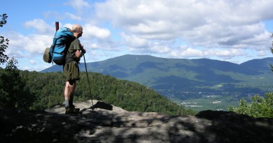
Best part: Standing atop Bondcliff, a 500-foot precipice, ogling an endless view of mountains without any evidence of civilization. Walking the knife-edge on Franconia Ridge between Mount Lafayette and Little Haystack.
Know before you go: For experienced backpackers. Requires a car drop for the four-day route. Save this one for good weather. Once above tree line, the route is extremely exposed.
THREE-NIGHTER: Monroe Skyline, Vermont
Day 1: Lincoln Gap to Glen Ellen cabin, 8.1 miles
Day 2: Glen Ellen cabin to Cowles Cove lean-to, 9.3 miles
Day 3: Cowles Cove lean-to to Montclair Lodge, 5.1 miles, then without packs, up and down Camel’s Hump (3.4 miles)
Day 4: Montclair Lodge to Monroe Trail trailhead, 2.2 miles
This classic section of the Long Trail cherry picks some of its best views. It starts with a short stiff climb to the top of Mount Abraham, one of Vermont’s four true Alpine areas. Once up high, it traverses the long ridge on the western side of the Mad River Valley, passing over Lincoln Peak and Mount Ellen before dropping down to Appalachian Gap. It climbs again over Burnt Rock Mountain then the Allens, saving the best for last, another of Vermont’s Alpine summits, Camel’s Hump. The undulating terrain is wooded and cliffy in places and rewards with excellent views along the high spine of the Green Mountains north and south, as well as to New Hampshire’s White Mountains to the east and the Adirondacks to the west.
Best part: Eating lunch atop the lesser-known open-rock summit of Burnt Rock Mountain. Exploring the cave by the Theron Dean Shelter on the descent to App Gap.
Know before you go: Requires a car drop. Overnight fee at lodges and lean-tos collected by Green Mountain Club caretaker.

TWO-NIGHTER: Avalanche Lake-Mount Marcy Loop
Day 1: Adirondak Loj to end of Lake Colden and the Beaver Point lean-to’s, 5.6 miles
Day 2: Lake Colden over Mount Marcy to Marcy Dam lean-tos, 8.8 miles
Day 3: Marcy Dam lean-tos to Adirondak Loj trailhead, 1.3 miles
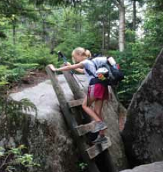
This two-nighter takes you into the heart of the Adirondack High Peaks. The first day, you’ll pass through a short, deep canyon known as Avalanche Pass then follow the shoreline of Avalanche Lake and Lake Colden via a series of short ladders and bridges, known as “Hitch Up Matildas” that hang dramatically from the boulders and cliffs. After a night near the lake, you’ll climb past Lake Tear of the Clouds, the source of the Hudson River, and over the summit of Mount Marcy, the highest mountain in New York. After ogling the view, you’ll descend past Indian Falls to the lean-tos along Marcy Brook near Marcy Dam. It’s an easy hike out the last morning, closing the loop at Adirondak Loj.
Best part: The summit of Mount Marcy on a blue-sky day feels like the top of the world.
Know before you go: Bear canisters are required for storage of food, toiletries, and trash when camping in the Adirondack Park. Rent one from the Adirondack Mountain Club at Adirondak Loj. Parking fee at Adirondak Loj trailhead.
ONE-NIGHTER: Stratton Mountain–Stratton Pond Loop, Vermont
Day 1: Long Trail-North from Kelly Stand Road ver Stratton Mountain to Stratton Pond, 6.9 miles
Day 2: Stratton Pond to Kelly Stand Road via Stratton Pond Trail, 4.6 miles
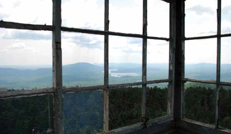
A visit to Stratton Pond is a nice introduction to backpacking if you’ve never done it before. Though the route takes you over Stratton Mountain, the climb is not steep and rewards with a spectacular view that extends into five states from atop a fire tower, a national historic landmark. Stratton Pond is the largest body of water on the Long Trail and a nice place to swim or cast a line. (The state of Vermont stocks Stratton Pond with brook trout.) There are a number of first-come, first-served tent sites at various points around the pond, as well as an oversized lean-to. And the walk out via the Stratton Pond Trail is relatively flat through an airy hardwood forest. To close the loop, it’s a 0.9-mile walk along the Kelly Stand Road (a seasonal dirt road) back to the trailhead for the Long Trail-North.
Best part: Climbing the fire tower. Watching the pond turn to glass as the sun sets.
Know before you go: Can be crowded on summer weekends when through-hikers and overnighters converge there. Overnight fee collected on site by Green Mountain Club caretaker.
For more info:
Vermont: Green Mountain Club
New Hampshire: Appalachian Club
New York: NYSDEC; Adirondack Mountain Club


