
An Insider’s Guide to Great Fall Foliage Hiking, Biking, and Paddling
Tourists from near and far will be filling their gas tanks and driving through Vermont admiring the palette of colors that residents enjoy every autumn. Luckily, readers of Vermont Sports are pluckier than those who need an internal combustion engine to see the sights. They know that some of the best ways to admire the views require muscle, not motors. Below are some of the best foliage hikes, bike rides, and paddling adventures recommended by experts across the state.
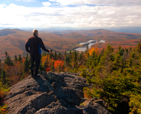
BY FOOT
Heinz Trebitz of the Ottauquechee section of the Green Mountain Club recommends that those looking for views should hike a section of the Rivendale Trail System, which includes the towns of Vershire, W. Vershire, and Fairlee, VT, and Orford, NH. The trail is 36 miles long and goes from Flagpole Hill in Vershire to Mount Cube in Orford. One of his favorite legs is a four-mile stretch that starts at a trailhead parking area on Bloodbrook Road in Fairlee and heads west to a ridge overlooking Middlebrook Valley. Trebitz describes the hike as one that has plenty of hardwoods, partly open meadows, and an intimate view. Trebitz also recommends a hike which starts across from the fishing access at Lake Morey in Fairlee and climbs up to Eagle’s Bluff. The trail can be turned into a four-mile loop by following signs to the Hulburt Outdoors Center and returning on the road next to the lake.
Mike Chernick, director of the GMC’s Northeast Kingdom section found it difficult to restrict himself to just one hike, but eventually settled on the Bald Mountain’s Long Pond Trail in Westmore, VT. The trail crosses some streams and travels through an open hardwood forest and a sub-alpine spruce-fir forest before finally reaching a rocky summit. There is a rebuilt fire tower at the peak that provides spectacular views. The hike is two miles long and has an elevation gain of 1,250 feet.
Down at the Bennington section of the GMC, Bill Lyons reported that his new favorite foliage hike leads to Eph’s Lookout just south of the border. The lookout can be accessed from Massachusetts Avenue. Lyons said the lookout is roughly three miles from either starting point and has stellar views of the Green Mountains and Mount Graylock. A shorter, but equally beautiful hike is Harmon Hill which can be reached going south from Route 9 in Woodford on the Long Trail. From the lookout on Harmon Hill, there are views of Bennington and Mount Anthony.
BY ROAD BIKE
Leslie Carew, co-touring chair of the Green Mountain Bike Club (full disclosure: I’m the other co-touring chair) recommends a ride the club calls Cabot Sampler. This 45-mile ride passes along the shores of both Lake Caspian and Lake Eligo and includes a stop at the famous Willie’s General Store in Greensboro. Start in Cabot and ride north on Routes 215, 15, and 16 to Greensboro Bend. Take a left on Bend Road and follow that to Greensboro. Go right on the E. Craftsbury Road, and in E. Craftsbury go left, coming out on Route 14. Go south to Hardwick and pick up Route 15 east to Walden. Go right on the South Walden Road back to Cabot. Carew considers the section through the town of Craftsbury to be particularly scenic.
Lou Bresee of Lake Champlain Bikeways is partial to a ride the organization calls Moosalamoo Meander. The 42-mile route starts at the parking lot of Shaw’s in Middlebury and travels along the shore of Lake Dunmore as far south as Forest Dale before heading back north through Ripton. In addition to the great scenery there is a swimming hole at Middlebury Gorge on the return trip and the opportunity to get off the bike and hike part of the Moosalamoo Region of the Green Mountain Nation Forest. There are two stores along the way which are suitable for refueling.
Joe Cook of the Putney Bike Club recommends yet another 42-mile loop (apparently a popular length) which begins at the Common in Townsend and proceeds north through Windham and Chester before heading back down on Route 35. There are two potential lunch stops along the way in Grafton and Chester. Cook notes that there is a short dirt section and some hills, but traffic is generally light. “The gradual descent along a brook and open fields into Grafton is spectacular,” he said, “and the long descent down Windham Hill Road reminds one of earlier times.”
BY BOAT
Cathy Frank and Margy Holden are the authors of A Kayaker’s Guide to Lake Champlain. Their recommendation for northern Lake Champlain is a paddle along the Missisquoi Delta. Frank said that in the fall the water is clear and there are no problems with blue-green algae. Paddlers can put their boats in at Louie’s Landing off Route 78 in Swanton. On a windy day, Frank recommends taking the river towards Swanton and Dead Creek. On a calm day, paddlers can venture onto the Almost Great Lake and paddle around two islands. In both cases, there are plenty of wildlife to be seen and beautiful colors.
On the southern part of the lake, the two are partial to paddling south of Crown Point, but note that the prime access points are currently closed for bridge construction. In addition, foliage season coincides with duck hunting, which is a popular activity in that area. For that reason, Frank suggests that those interested in exploring the southern part of the lake should put their boats in at Arnold Bay in Panton and paddle up to Button Bay or even as far as Kingsland Bay. Frank said the Vermont side of the southern end of the lake has more deciduous trees than the New York side.
Jane Yagoda of True North Kayak Tours is partial to a paddle that begins at the Kingsland Bay fishing access on Hawkins Road in Ferrsiburg. From there, paddlers can take Little Otter Creek as it winds through a marshy area, teeming with plants and animals. When the creek emerges onto Lake Champlain, paddlers can travel the shoreline, admiring the patterns in the rocks and stopping for lunch at Kingsland Bay State Park or the town beach in Ferrisburgh. Yagoda also enjoys a paddle up the Lamoille River from a put-in on Bear Trap Road in Milton that features spectacular cliffs and hardwoods.
Jim Walker of Battenkill Canoe recommends the Somerset Reservoir in Windham County, which he describes as “isolated and well forested.” The Reservoir can be accessed off Route 9 near Wilmington. Although Walker praised the entire 40 miles of the Batten Kill as scenic, he suggested a three-hour paddle starting from the Rochester Bridge in Arlington and heading down to New York. That section passes under a covered bridge in West Arlington and provides a mix of mountain views and pasture land.
So there you have it. Leave the internal combustion engines to the tourists and admire Vermont’s foliage up close and personal.
For more scenic and inspirational fall foliage road bike rides,
go to This Month vtsports.com feature story by Kirk Kardashian, Colorful Road Bike Rides, at www.vtsports.com/articles/colorful-road-bike-rides
MORE INFO
Hiking
Cross Rivendell Trail, www.crossrivendelltrail.org
Green Mountain Club, www.greenmountainclub.org
Road Biking
Green Mountain Bicycle Club, www.thegmbc.com
Lake Champlain Bikeways, www.champlainbikeways.org
Putney Bike Club, www.putneybicycleclub.blogspot.com
Paddling
A Kayaker’s Guide to Lake Champlain, www.kayakinglakechamplain.com
True North Kayak Tours, www.vermontkayak.com
Battenkill Canoe Ltd – www.battenkill.com