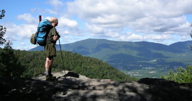
12 Great Summer Hikes
From Mount Equinox to Mount Mansfield, we’ve rounded up 12 day hikes around Vermont for you to add to your summer bucket list.
This article was originally posted on July 9th 2014 with the title “12 Great Summer Hikes for 2014”
Quechee Gorge: Quechee, Vermont
For a Vermonter who drives over the Gorge regularly, but has never taken the time to climb down to the gorge, Quechee Gorge is well worth the stop. Part of the 612-acre Quechee Gorge State Park in the village of Hartford, Quechee Gorge is perfect for sightseers and hikers alike.
Route 4, which runs above the gorge, looks down from an impressive height of 165 feet onto what is often called “Vermont’s Little Grand Canyon.” Formed by glacial activity roughly 13,000 years ago, Quechee Gorge is Vermont’s deepest gorge and makes for a stunning hike.
Trails lead down to the river below, offering hikers a view of the Ottauquechee River not experienced from above, and along the gorge for a mile and can be taken to the head of the gorge where a woolen mill once stood in the 1800s. Although the mill closed in 1952, remains of the dam attached to it can still be seen as part of Mill Pond Falls.
From I-89 north take exit 1 to US 4 and travel three miles west.
Quechee State Park | 5800 Woodstock Road | Hartford, VT 05047
For more information: visit www.vtstateparks.com/queechee or call the Park Phone (802) 295-2990
Wildlands Trail: Killington, VT
It was from the top of Killington Peak, the second-highest peak in Vermont, that Reverend Samuel Peters first called the surrounding land “Verd Mont” or “green mountain.” When Vermont later became a state named after this declaration he was reportedly upset by the missing “d,” insisting that the name “Vermont” was too similar to vermis, latin for vermin. Convinced that it should have been named “Verdmont” instead, the Reverend’s ghost is rumored to haunt Killington to this day, with reported spectral appearances and unidentified ghostly voices.
Ghost stories aside, Killington is home to a ski resort as well as parts of both the Appalachian and Long Trails. The Wildlands Trail is a beautiful, nature-oriented climb to the 4,241-foot high summit. From the K-1 base lodge it’s a 2.2-mile walk to reach the top. Winding through the Northern hardwoods, upper transition and Boreal forests, the Wildlands Trail offers stunning views of surrounding mountains and plenty of places to catch your breath.
The summit reaches above the tree line and offers a view of southern and central Vermont, New Hampshire, New York and Massachusetts. Among the landmarks to look for at the top are Mount Pico, the Adirondack Mountains, Champlain Valley, Mount Abraham, Camels Hump, the White Mountains, Mount Equinox, Glastenbury Mountain, and Vermont’s highest peak: Mount Mansfield.
Free parking is offered at the lodge, where one-way or round-trip gondola tickets to the summit can also be purchased. Killington resort is in central Vermont at the junction of US 4 and VT 100 North in Killington, 11 miles east of Rutland. Continue past Snowshed and Ramshead lodges on the Killington access road to reach the K-1 lodge.
Killington Resort | 4763 Killington Road | Killington, VT 05751
For more information: call (802) 422-6201, email info@killington.com or visit www.alltrails.com
Mount Ascutney: Windsor, Vermont
Although located in Vermont, Mount Ascutney’s geologic history is more closely related to that of New Hampshire’s White Mountains. Formed over 100 million years ago by magma pushing upwards into neighboring metamorphic rock, erosion has left the igneous granite rock peak rising 3,144 feet above sea level. Four trails run from base to the summit of Mount Ascutney: the Futures Trail, Weathersfield Trail, Brownsville Trail and Windsor Trail.
The Brownsville Trail offers hikers views of the Norcross Quarry, a granite quarry from the early 1900s, as well as excellent views from Quarry Top Lookout, Knee Lookout, North Peak Lookout and Brownsville Rock, which is also the mountain’s hang-gliding launch site. The 3.2-mile hike leads to Ascutney’s summit, where a 24.5-foot observation tower provides a striking view of the surrounding countryside. The tower is located on the Brownsville Trail just north of its intersection with the Weathersfield Trail.
Trailhead parking is found off Route 44 in Windsor. From the Mount Ascutney State Park office travel 1.8 miles north on Route 44A to its junction with Route 44. The Trailhead is one mile to the left along Route 44 traveling west.
Mt. Ascutney State Park | 1826 Back Mountain Road | Windsor, Vermont 05089
Park Phone: (802) 674-2060 Open for day use: 10:00 AM – Official Sunset
Mount Tom: Woodstock, Vermont
Faulkner Trail on Mount Tom ends in a breathtaking view of the Woodstock Village and surrounding mountains seen from the south side of the mountain. This easy going hike is 2.75 miles round trip leading to an elevation of 1,250 feet, the last 100 yards becoming slightly more challenging due to rocky and uneven footing. The path switchbacks most of the way up, stopping before the top at a serene overlook spot with benches.
After reaching the top further possibilities of exploration are possible; the trail is connected to the Marsh-Billings-Rockefeller National Historical Park, which can be explored from the South Peak by taking the Mount Tom Road and then Mountain Road. This trail leads to the Pogue, a man-made 14-acre pond (rumored to be bottomless) located in the park’s Mount Tom Forest. For those seeking a challenge, a hike to the North Peak of Mount Tom provides rewarding views of King Farm, Killington, Mt. Ascutney, Kendron Valley, the Woodstock Inn, Windsor Court House and covered bridge, Mt. Peg and Billings Farm. North Peak is the summit of Mount Tom at an elevation of 1,359 feet and can be reached by the North Peak Trail.
To reach the Faulkner Trail go to Faulkner Park from Woodstock Green on Route 4, taking a right on Mountain Road and continuing to a parking pull off at the park. Follow the paved paths into the park to a kiosk, where the hike begins.
Marsh-Billings-Rockefeller National Historical Park | 54 Elm Street | Woodstock, VT 05091
Visitor Information (802) 457-3368 ext 22
Shaw Mountain and Shaw Mountain Natural Area in Benson and West Haven
Shaw Mountain Natural Area is a 600-acre site preserved by The Nature Conservancy and is perfect for hikers looking for a calm walk with a focus on nature. In addition to Shaw Mountain, a limestone mountain rising over 500 feet, the surrounding natural area is home to 11 different plant communities, including a shrub swamp, vernal pools and an oak-hickory forest. The area is also home to 15 rare plant species, including the three-lobed violet, yellow oak and snowy aster. With wild turkeys in the oak hickory forests, spotted salamanders breeding in the vernal pools, and bobcats living in the rocky ledges, Shaw Mountain and the surrounding area is a prime location for viewing wildlife. Beginning at the preserve parking area, a 2.4-mile nature trail leads around the area, providing visitors a firsthand experience of the biodiversity Shaw Mountain and Natural Area has to offer.
Follow signs to Benson from Route 22A in Fair Haven until the stop sign. Go straight, then turn onto Parkhill Road and drive for half a mile. Take a right onto Money Hole Road and travel until the Conservancy sign appears to the left, where the trail begins.
Contact the Nature Conservancy with any questions at (703) 841-5300
Mount Equinox: Manchester, Vermont
Although the Skyline Drive, a privately owned toll road, takes drivers to the summit of Mount Equinox, a hiker is privileged to a first-hand experience of Mount Equinox’s two different ecosystems. The lower elevation system is home to whitetail deer, moose, bobcat, black bear, fisher cats and a variety of plant life. Above 2,800 feet a new ecosystem begins containing peregrine falcons, eagles, snowshoe hare and plant life such as balsam trees, lichens and mosses. The mountain is a natural aquifer, replenishing groundwater for surrounding areas, and is used to study environmental impact on water and air quality and invasive species.
Located in the town of Manchester, Mount Equinox is the highest point in the Taconic Mountain Range at an elevation of 3,848 feet. The summit can be reached by experienced hikers, and is a four-mile climb from Manchester on the Burr Burton Trail. This trail can also be reached from the Red Trail that, for those not eager to conquer the summit, leads to Lookout Rock. From Lookout Rock, hikers have an excellent view of Manchester Valley, the White Mountains, Mount Ascutney, and Mount Monadnock. For a calmer hike, Lookout Rock can also be reached via the Yellow Trail.
The primary access point is the green entrance gate at the designated parking to the Red Gate Trail. Drive west on West Union Street and turn right at the end of the paved section. The gate is a short distance below the Red Gait Trail.
Skyline Dr | Arlington, VT 05250
(802) 362-1114
Mount Mansfield, Sunset Ridge Trail or Long Trail, Stowe
At 4,300 feet, Mount Mansfield is Vermont’s highest peak. There are countless trails, including the Long Trail, to choose from when hiking Mansfield.
On the eastern side is Stowe’s Smuggler’s Notch State Park for those interested in the history of the mountain pass. The trailhead lies along highway 108, including an access point to the Long Trail following the Toll Road, parking, and then hiking following the white blazes above the tree line. This walk (from the top of the Toll Road) leads to the summit after a 1.2-mile hike and offers a 550-foot elevation gain. Another trail leaves from a mile or so below Smuggler’s Notch and hikes up the northern side of the Long Trail. It’s a two-plus mile hike and fairly strenuous. For the casual hiker, plan on three hours round-trip.
Smugglers Notch State Park 6443 Mountain Road Stowe, Vermont 05672; 802-253-4014
The most common method of reaching the summit of Mount Mansfield is Sunset Ridge Trail on the West side of the mountain. The elevation and harsh climate on this side of the mountain result in vegetation found along the summit’s ridge similar to that of the Arctic tundra and is extremely rare for Vermont. Head North from the CCC road for 1.4 miles until intersecting with the Long Trail. Follow the Long Trail 0.2 miles to the chin, the highest point of the mountain. The CCC road can be reached from the Mountain Road in Underhill State Park in Underhill, Vermont.
Underhill State Park | 352 Mountain Road Underhill | Vermont 05490
(802) 899-3022
Devil’s Gulch: Eden, Vermont, 5-mile loop
Only 0.2 miles long, this section of the trail known as Devil’s Gulch is one of the most difficult portions of the Long Trail due to the rocky terrain and occasional maneuvering around boulders it takes to hike. Part of the Long Trail State Forest, the gulch is home to many amphibians amongst the boulders and crevices covered in ferns and moss.
Crossing Route 118 and entering the woods, the trail slowly begins a climb to its high point at 1,580 feet. It then begins a descent to Ritterbush Outlook, providing a view of Ritterbush Pond and nearby hillsides. Heading down, the hiker comes to a junction with Babcock Trail, eventually climbing 0.4 miles to the Eastern Entrance of Devil’s Gulch.
Once in the Gulch, the trail leads over slippery logs, under a small cave, and through fallen rocks and boulders, perfect for exploring. The Gulch ends, returning the hiker to Babcock Trail. The rest of the trail leads to the Southern end of Big Muddy Pond, winds through young forests, and then weaves around the North end of Big Muddy Pond, descending back to Route 118.
This five-mile loop is moderately difficult. For hikers looking for more of a challenge, following the Long Trail North from the parking lot leads up Belvidere Mountain. Taking the Forester’s Trail after 2.6 miles leads to the summit for views of Northern Vermont and Southern Quebec.
Follow route 118 West for 4.8 miles from the junction of Routes 100 and 118 in Eden. Turn right to follow a dirt road a few hundred feet to the parking area.
For more information: call theGreen Mountain Club (802) 244-7037 or visit www.alltrails.com
Mount Philo, Charlotte, Vt.
Mount Philo, the heart of Mount Philo State Park, stands out in the Champlain Valley landscape, offering views of Lake Champlain and the Adirondacks beyond. The round trip is 2 miles for an elevation gain of 650 feet, to a total elevation of 968 feet above sea level. The trailhead is off the State Park Road. Mount Philo is known for its wildflowers and maples, which make it a particularly popular destination in the fall. The summit of the mountain has a picnic area on an open cliff. On clear days, hikers can see Whiteface Mountain near Lake Placid, N.Y. from Mount Philo’s summit.
Mt. Philo State Park | 5425 Mt Philo Rd. | Charlotte, Vermont 05445
Park Phone: (802) 425-2390
Mount Independence, Orwell, Vt.
This mountain, named for the Declaration of Independence in 1776, is located in Orwell, along the southern shores of Lake Champlain. As its name suggests, it has a revolutionary pedigree: soldiers were stationed here, across from Fort Ticonderoga, during the Revolutionary War, as it was a strategic position. A hike on Mount Independence is a walk back in time. The mountain itself is really more of a bluff stretching out into a narrow part of Lake Champlain.There are four trails, ranging from 0.6 to 2.5 miles. A hike from the Blue Trail to the Orange trail provides most of the significant scenery. This round trip is 2.9 miles, with an elevation gain of 200 feet, for a final elevation of 306 feet. This loop yields a number of views of Lake Champlain, and winds its way through a number of former military sites.
Mount Independence State Historic Site | 497 Mount Independence Road | Orwell, Vermont 05760
Phone: (802) 759-2412 or in season: (802) 948-2000
Mount Abraham, Bristol
This longer trail rewards hikers with a panoramic view of the Adirondacks, Whites, Green Mountains, and Lake Champlain from one of the most breathtaking summits in the area. The elevation gain, 2200 feet, is significant, and the round trip is 5.7 miles. The hike is along the Long Trail, though at the 1.7-mile mark it is intersected by the Battell Trail, an access trail. Don’t get turned around here on your way back down.
The summit is populated by rare, endangered arctic vegetation, so stay on the trail. The trailhead for this approach is on Lincoln Gap road. Coming from Route 100, travel about 4 miles up Lincoln Gap Road, to the second dirt parking area, where the trail starts at the top of the gap.
For more information, visit www.summitpost.org
Rattlesnake Cliffs, Salisbury
Hiking up to Rattlesnake Cliffs (and on up to the top of Mount Moosalamoo) from the Silver Lake/Falls of Lana trailhead is a great half-day trip of moderate difficulty. The elevation gain is 870 feet over 5 miles (add another 2/3 miles and elevation to the summit). Park at the Silver Lake/Falls of Lana trailhead off Route 53. Take the Silver Lake trail until the Rattlesnake Cliffs trail branches off to the left (1/4 mile past Falls of Lana). The trail passes the Aunt Jenny trail, which links back up with the Rattlesnake cliffs trail and can be taken as a loop. After reconnecting with the Aunt Jenny trail, the Rattlesnake Cliffs trail branches left again and leads to two overlooks with fantastic views of Silver Lake, Lake Dunmore, and the Adirondacks; a spectacular vista.
On the way down, take the first left onto the Oak Ridge trail. Take this trail until it is intersected by the Keewaydin trail. Take a right here and follow this trail until it connects with the North Branch trail for a full circuit back to the beginning of the Rattlesnake Cliffs trail. Peregrine falcons nest on the cliffs so hiking is prohibited in spring through early summer. Check with local forest service areas for times when the trail is fully open… generally early July though winter.
Moosalamoo Association | PO Box 148 | Brandon, VT 05753
For more information: visit www.trailfinder.info.com or email contact.moosalamoo@gmail.com