Jerry’s favorite hikes: Mount Mansfield
By
Jerry Grange
Posted November 1st, 1999
Editor’s note: This is the fifth and last of a series of hikes adapted from Jared (Jerry) Gange’s book, 100 Classic Hikes of the Northeast (Huntington Graphics, 802-660-3605), due out soon. Each hike has a description, photo, and directions to the trailhead. The five hikes are some of Jerry’s favorite picks from his book.
Maple Ridge Trail
Rating: Moderately strenuous; a few difficult spots.
Time: 5 hours
Distance: 5.2-mile loop
Elevation gain: 2,550′
Location: On the west side of Mount Mansfield, above Underhill Center.
Summary: A challenging and unusual climb, with great close-up views of Mansfield’s west flank and distant views of Lake Champlain.
Trail notes: There are two obvious ridges on the west side of Mount Mansfield: Sunset Ridge drops off the summit, while to the south, Maple Ridge descends from the Forehead, the flattish knob just to the south of the Nose. Probably because it doesn’t lead directly to the summit, Maple Ridge is much less popular than Sunset Ridge. However, it is a more varied route and, if you like a little rock scrambling, more fun.
To do the loop presented here, we will use five trails, i.e. five different named trail segments. From the Stevensville parking lot, walk up the gated road about 0.2 mile where the Frost Trail and Butler Lodge Trail depart to the left. Take the Frost Trail (you will return on the Butler Lodge Trail), and climb in woods to gain the ridge proper, where the Maple Ridge Trail comes in from the left, at 1.4 miles. From here on, you are increasingly out in the open, and the cairn-marked route twists and turns as it navigates improbable rock formations. Note: This is a challenging route for most dogs.
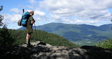
On the ascent there is a jump across a rock crevice and a couple of short, steep rock slabs. The final climb (0.2 mile) to the top of the Forehead is actually on the Wampahoofus Trail, a rough feeder trail between Maple Ridge and Butler Lodge. There are excellent views from the semi-open Forehead (see photo). Hiking distance to this point is 2.5 miles, and on average will take a little over two hours. The side trip over to the Nose adds 1.5 miles to the trip, and is worth the effort.
To continue on the loop, pick up the white-blazed Long Trail and head south (right). The upper part of this open, south-facing ridge is spectacular, especially in afternoon light. Lower down, there are a couple of difficult sections with ladders that require caution and are very challenging for dogs (and their owners!). Immediately after passing through the rock feature known as the Needle’s Eye, and reaching easier terrain, watch for the Butler Lodge Trail (there is a sign) which comes in from the right. Head down to Butler Lodge, a primitive cabin with accommodations for about 14 people. From here it is 1.8 miles of pleasant downhill walking back to your car. You close the loop when you return to the woods road (bottom of the Frost Trail), a few minutes from the parking lot.
Approach: From the west (Burlington area) take Route 15 to Underhill flats, and bear right on River Road to Underhill Center. From the stop sign (general store), continue 0.2 mile, then turn right on Stevensville Road. Follow this to the end—it turns to gravel at 1.1 miles—and the small parking area is 2.8 miles from Underhill Center.
Maps and references: Hiker’s Guide to the Mountains of Vermont, p. 20; Long Trail Guide, p. 142, 151-3; Northern Vermont Hiking (map); Vermont Atlas and Gazetteer, p. 45-46.