
Hike the Whites! Four Classic Hikes in New Hampshire
My hiking preferences have migrated east over my lifetime. I grew up in the Adirondacks, summiting iconic 4,000-footers such as Mount Marcy, Whiteface and Algonquin Peak, which scratch the sky with their bald rocky pates.
In the 1970s, I went to high school in southern Vermont where I discovered equally iconic peaks in the Green Mountains. The Green Mountains were different though.
After climbing Vermont’s five 4,000-footers, I sought views from historic fire towers, first atop well-known high points such as Stratton Mountain and Mount Ascutney and then more obscure spots such as Mount Belvidere and Spruce Peak.
Then, I went on a college orientation camping trip in New Hampshire’s White Mountains and discovered a delightful combination of bald summits and tantalizing towers. Hiking in the Whites is pure delight.
Over the last 25 years, and after writing five hiking guidebooks covering the Adirondacks, the Green Mountains, and the White Mountains, the White Mountains are my favorites, and not because the range has the most 4,000-footers (which it does, 48 of them). I love the Whites because they reward hikers with the most variety. Whether I’m poking up a trail with my camera or my kid, carrying a load on a multiday trip, or simply looking for some exercise and fresh air, I have not one or two, but dozens of options.
Most important, the White Mountains reward with endless views. That’s the real reward. I love jumping in a chilly swimming hole or discovering a secluded clearing in which to pitch my tent, but what ultimately entices me is the promise of an expansive panorama. Sitting atop a peak lifts me above my daily cares. It sets me free. For a short time, I can forget my responsibilities and simply enjoy the moment.
Here are few of my favorite White Mountain peaks where I always feel on top of the world:

Mount Cardigan (3,121 feet)
Nearest Town: Orange, New Hampshire
Total Distance: 3 miles, out and back
Vertical Gain: 1,220 feet
Canine Compatibility: Dog-friendly
Trailhead Coordinates: N43 38.717 W71 56.249
With an expansive bald top, a fire tower, and a 360-degree view, it is hard to find a hike with a better reward for such a modest effort than Mount Cardigan. I usually go up the West Ridge Trail, a kid- and dog-friendly route. The path traverses more and more slab as you climb, eventually passing among low blueberry bushes before breaking into the open.
Although technically not above tree line, the top of Mount Cardigan is an expansive bare dome thanks to a forest fire back in the 1800s. It takes about 10 minutes to cross the rocky summit area to the fire tower. The tower is usually closed, but you can climb the stairs. On a clear day, you can see the Franconia Ridge to the east beyond Newfound Lake, with Mount Washington in the distance. Mount Sunapee (the ski area) and Mount Kearsarge (fire tower on top) lie to the south. Mount Ascutney in Vermont dominates the western view.
Contact: New Hampshire Division of Parks and Recreation, (603) 271-3556, nhstateparks.org.

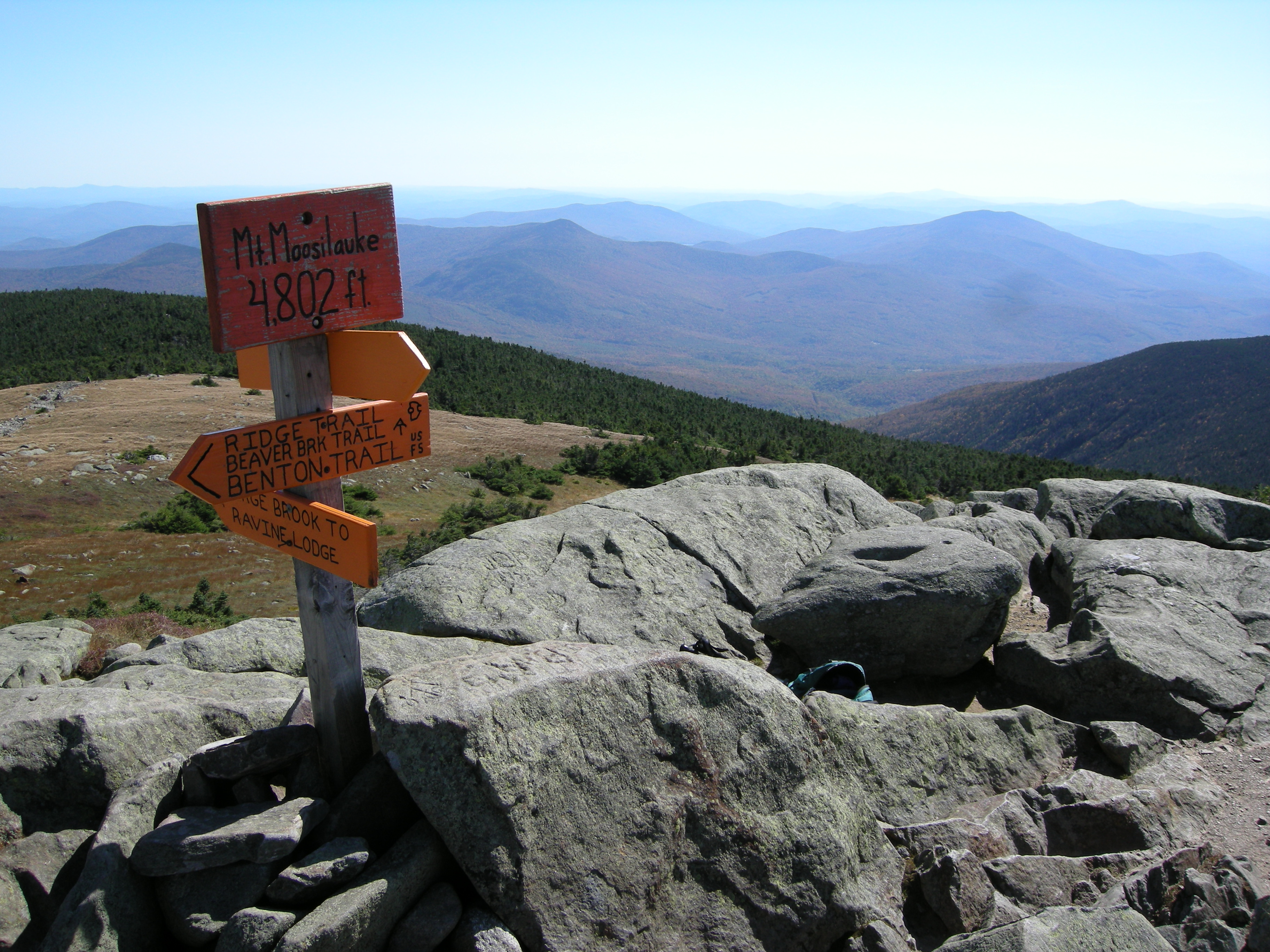
Mount Moosilauke (4,802 feet)
Nearest Town: Warren, New Hampshire
Total Distance: 7.6 miles, loop
Vertical Gain: 2,550 feet
Canine Compatibility: Dog-friendly
Trailhead Coordinates: N43 59.598 W71 49.016
Mount Moosilauke is the western-most 4,000-footer in the White Mountains and the dominant mountain along the Upper Connecticut River Valley. It is a hulk of a peak with a sprawling open summit, the 10th highest in New Hampshire.
The name “Moosilauke” has nothing to do with the large-hoofed beast common to its slopes. It is derived from the Abenaki Indian words “moosi” and “auke,” which mean “bald place.” About 100 acres of the mountain is above tree line.
There are a half-dozen ways to hike Moosilauke. I like ascending the Gorge Brook Trail, then descending via the Carriage Road to the Snapper Trail. The lower Gorge Brook Trail was part of the famed Hell’s Highway ski trail where the first U.S. Downhill Championships were held in 1933. The Snapper Trail was also originally cut for skiing. Today, the entire route is a well-maintained footpath.
The lower Gorge Brook Trail follows its namesake brook, climbing moderately. At 1.6 miles, the trail leaves the brook behind and angles up the mountain in a northerly direction. There are several cuts in the trees offering nice views, but the real treat begins at 3.5 miles when the trail breaks from the krummholz. An impressive view of the Franconia Ridge and Presidential Range lies to the northeast beyond the lawn of alpine sedges and mountain cranberries.
In 1860, local businessmen built a summit house, accessible by carriage road, but in 1942, it was struck by lightning. All that remains today are parts of the old stone foundation, which offer hikers welcome protection from the wind.
From the summit, the Carriage Road/Appalachian Trail-South (white blazes) heads across the broad alpine expanse toward the mountain’s southern sub-peak, eventually reaching the junction with the Snapper Trail. From there, the descent continues through airy woods back to lower Gorge Brook, closing the loop.
Contact: Dartmouth Outing Club, (603) 646-2834, dartmouth.edu/~doc/

Franconia Ridge
Nearest Town: Franconia, New Hampshire
Total Distance: 7.9 miles, loop
Vertical Gain: 3,850 feet
Canine Compatibility: Experienced dogs only. Dogs are not allowed inside the AMC Greenleaf Hut.
Trailhead Coordinates: N44 08.554 W71 40.938
The Franconia Ridge is one of the most dramatic alpine ridge walks in the northeast. I like to ascend via the Falling Waters Trail to the top of Little Haystack, cross the ridge over mounts Lincoln to Lafayette, then descend via the Old Bridle Path to close the loop. Some prefer to hike the loop in reverse, although I find the Falling Waters Trail easier to go up than down, especially if conditions are wet.
The grade is easy at first through a hardwood forest then becomes more persistent, passing several small cascades as it climbs. At 1.3 miles, the trail passes Cloudland Falls, an 80-foot cascade. By 2.7 miles, views of South Kinsman appear across the valley. A moment later, a spur leads to Shining Rock Cliff, where you’ll find a more extensive view of the Kinsman Range and Mount Moosilauke farther to the west.
At 3.2 miles, the trail clears the tree line just before meeting the Franconia Ridge Trail, by the summit of Little Haystack. At 4,760 feet high, Little Haystack is hardly little; however, it is considered a sub-peak of Mount Lincoln.
Atop Little Haystack, the route turns north on the Franconia Ridge Trail/Appalachian Trail (AT). Once on this alpine knife edge, the views are boundless to the east across the Pemigewasset Wilderness, and to the west all the way to the Green Mountains.
After reaching Mount Lafayette, the high point of the loop, the route drops down through a scree field toward the AMC Greenleaf Hut just beyond Eagle Lake, a small alpine tarn. Cannon stands in rugged splendor across Franconia Notch for most of the way down to tree line and the hut.
The Old Bridle Path Trail departs to the left of the hut, allowing yet more impressive views, until the evergreens and birches take over, this time across Walker Ravine. At 8.5 miles, the Old Bridle Path meets the Falling Waters Trail again, closing the loop.
Contact: Appalachian Mountain Club, (603) 466-2721, outdoors.org.

Mount Washington (6,288 feet)
Nearest Town: Bretton Woods, New Hampshire
Total Distance: 9.2 miles, out and back
Vertical Gain: 3,800 feet
Canine Compatibility: Not dog-friendly due to extensive boulder field on summit
Trailhead Coordinates: N44 16.170 W71 20.953
Mount Washington is the tallest, not only in the White Mountains, but in the entire Northeast. It dominates the view from many summits in New Hampshire as well as from high points in Vermont on a clear day. This lofty summit is accessible by car and cog railway. It is far from a wilderness experience at the top, but I include it because it’s on virtually every hiker’s bucket list in the region.
There are trails to the summit from every direction. The Ammonoosuc Ravine Trail from the west is one of my favorites for several reasons. First, although a hefty 4.6 miles and almost 4,000 vertical feet from the trailhead to the summit, it is one of the shortest routes up this formidable peak. In addition, it climbs beside a series of cascades en route to the AMC Lakes of the Clouds Hut and its two namesake ponds, which are the source of the Ammonoosuc River.
From the trailhead, the path follows the Ammonoosuc River, which is more brook than river here. The trees begin to get scrawnier and more weathered as you come to Gem Pool, a clear pool of water at the bottom of a low mossy waterfall.
At 2.5 miles, the first view toward Bretton Woods opens to the west. Soon, Mount Washington and the Presidential Ridge tower above you. You can hear the whistle of the cog railway and see the dark plume from its smokestack throughout the upper part of the climb.
The trail clears tree line and the grade eases just before reaching Lakes of the Clouds Hut at the junction with the Crawford Path/Appalachian Trail. From the hut, the trail passes between the two Lakes of the Clouds, then continues to climb over rocks and slab toward the summit.
The summit of Mount Washington has been dubbed “The Rock Pile” and for good reason. The summit cone is a massive jumble of boulders. Interestingly, though New Hampshire’s nickname is The Granite State, the rock pile on Washington is mainly mica schist and quartzite. The view is spectacular, reaching into four states (New Hampshire of course, plus Maine, Vermont, and New York), the province of Quebec in Canada, and the Atlantic Ocean. About 60 percent of the time, clouds shroud the peak, and it’s almost guaranteed to be windy and cold, maybe even snowing, regardless of the month, so be sure to pick your day wisely for this hike.
Contact: Appalachian Mountain Club, (603) 466-2721, outdoors.org.