Andean Adventure
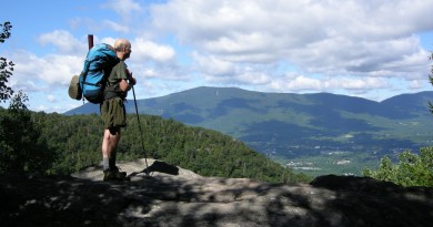
I suppose it’s sacrilegious for an intrepid hiker to go to Peru for the first time and not trek the Sacred Valley to Machu Picchu, but it was a conscious decision which I don’t regret. Hike the famous Inca Trail to a famous world heritage site with hundreds of people? Or hike a not-so-famous Incan trail into some of the highest, most beautiful snowcapped peaks in the world, with a few head of cattle and a couple of watchful caracaras for company? The more I contemplated a Peruvian trek, the more Machu Picchu sounded mucho crowded, and the more the Cordillera Blanca seemed cordial to backpackers in search of an alpine experience.
Located in the northern Peruvian Andes at eight degrees south latitude, the Cordillera Blanca is the highest mountain range in the world, outside the Himalayas. Twenty-two peaks in the range pierce the sky at over 6,000 meters, including the highest peak in Peru, Nevado Huascaran. Huascaran is no gentle giant. In 1970, a landslide from the mountain buried the town of Yungay, killing its 18,000 inhabitants. The slide was triggered by an earthquake, which claimed a total of 70,000 lives, the largest natural disaster in the history of Peru. The only survivors in Yungay stood atop a small hillock, laced with catacombs and crowned by an enormous Christ statue, whose arms spread wide toward the summit.
I stopped at the sight of the buried city en route to the trailhead for our trek. It made me wonder how vulnerable we would be if a similar earthquake occurred. The Cordillera Blanca is extremely active geologically, something as a resident of benign New England I never thought to check before arranging this trip. Luckily my worries proved unfounded. Though the geology I would traverse did not shake me physically, it moved me deeply as only the highest, most majestic mountains can do.
I selected one of the classic routes in the region known as the Santa Cruz Trek, a four-day route which follows the Santa Cruz River to its source, crosses the Continental Divide at Punta Union Pass and then traverses through several remote villages to the town of Vaqueria. Our guide, Hisao Morales, was an accomplished mountaineer, who owned a local climbing school. My trekking partner was a college friend, Debbie Hannam, who hikes with me in Vermont and New Hampshire in the summer and who has been my trekking partner on two other far-flung expeditions, one to Bhutan and the other to Ethiopia. Our small band also included Hisao’s father, Pablo Morales, an expert on local flora and one of the original “mountain men” in the region; Estefan, our cook; and “Juan” who owned our pack mules. (I called him “Juan” because his native name was indiscernible.)
We convened at the trailhead at the mouth of a narrow canyon. The path approached the canyon beside an old stone aqueduct, brimming with clear blue-green water, typical of glacial runoff. We passed a large wooden cross, fully five feet high and four feet wide. Faded scarves and a brass vase full of flowers adorned the trailside shrine. Hisao paused briefly in prayer and then continued along the aqueduct. I asked if the cross honored a person who had met an untimely death in the mountains. But that was not the case. It was merely a Peruvian version of prayer for safe passage in the high country, similar to the incense and prayer flags that the Buddhist sherpas use in the Himalayas.
We passed through an old wooden portal and quickly turned into the canyon alongside the Santa Cruz River. The spray from the angry rushing river created two eco-systems in one narrow place. Cactus grew under the cliffs, while tropical bromeliads clung to trees and rocks near the water. What fascinated me most were the wildflowers. The canyon was a wildflower garden. I paused to look at a small blue specimen with a yellow center, less than an inch in diameter and only about two inches off the ground.
“What’s this one called?” I asked.
“Penqa penqa,” replied Pablo, who didn’t speak English.
“That’s the Quechuan name. The common name is Vergonzosa,” added Hisao, though Vergonzosa didn’t sound familiar, either.
Hisao explained that the tiny bloom was a member of the gentian family that grows in high meadows, or pampa, above 13,000 feet. His elevation information about the flower merely confirmed what my lungs already knew. We were high, and we had barely started. This trek would test of my altitude tolerance. The route was entirely over 12,000 feet. It would top out around 15,000 feet at Punta Union Pass. I had been that high once before, atop Mount Rainier, but that was only for an hour or two, not for several days. And I had never slept that high, but I felt fine so far, as long as I didn’t try to sprint up the trail.
Pablo was another matter. In his late 60s, the man was a hiking machine. His pace was strong and steady. He halted only when he came upon a plant worth mentioning to us. This happened fairly often, which was lucky for both my lactic acid-laden legs and for my education. Each plant along the trail seemed to have a homeopathic use. Pablo enthusiastically schooled us on the local way to cure liver disease, intestinal problems, and heart disease. Women could relieve menstrual cramps, have smoother baby deliveries, and fewer menopausal symptoms by brewing a tea from the correct plant. There were even plants to erase freckles! More interesting was the fact that two-thirds of the alpine flowers I passed were unnamed and not scientifically cataloged, an unfathomable concept to someone from the U.S., where everything seems over-analyzed and micro-categorized.
The sheer rock walls eventually separated enough to reveal the high snowy peaks we had come to see. Nevado Alpamayo, a distinctive pyramid of rock and ice loomed large among the other glaciated giants on the left side of the canyon. We camped the first night at Llamacorral, which was literally a stone corral in the middle of the pampa. Though a designated campsite, it was also an active pasture, though not for llamas. A couple of mangy cows had claimed the corral as their own. I felt like I was in Switzerland, looking at the cows and the snowcapped Alpen peaks, only the peaks were 5,000 feet higher.
For three days, we traversed the pampa, gradually closing on Punta Union Pass. On the second day, we took a side trip to Alpamayo basecamp. Only one expedition was on the mountain at the time, as evidenced by the cook tent they had left behind. My vision of an expedition basecamp was from Everest, a barren scree field dotted with colorful tents and prayer flags. This basecamp was nothing of the sort. It was lush with flora. Moss dripped from the trees. Two caracara, Andean raptors the size of eagles, surveyed the small plateau from atop a barren branch. It was a wet afternoon. The rain dampened our bodies and our spirits, but we trudged several more miles past a high tarn to our next camp at Taullipampa, named for the massive mountain that formed the left side of the pass that we would soon climb.
We crossed Punta Union Pass on the third day. As I toiled up the ancient Incan steps, climbing ever higher toward the snow line, I marveled at the trail work. The route I ascended predated the Incas. It was first used by the Wari culture to transport goods from the Amazon basin to the Pacific Ocean in much the same way that my bag now bumped up the trail, though more likely on llamas. Domestic horses and their derivatives (mules, donkeys) were introduced to South Americans by the European conquistadors, who were ultimately credited with the downfall of the Incan Empire.
As we crested the ridge at a narrow gap in the rock, my heart threatened to beat out of my chest, as much from the view as from the lack of air. To my back, the entire Santa Cruz Valley wound its way past endless mountains. To my front lay a great barren cirque, dotted with pools of water. A thread of trail ran through the massive plateau to the horizon. We passed along that thread, eventually camping among scrubby trees at the convergence of two valleys.
The last day was a muddy mess. We passed shepherds herding their sheep and young children who ran to us out of curiosity. We passed another tall wooden cross, this time with an elderly woman and her dog next to it. With Hisao as interpreter, I asked if I could take her picture. She said it would cost me a piece of candy, which I was glad to proffer. I figured it wouldn’t damage her dental work as she hadn’t any teeth.
The trek ended in Vaqueria, which was little more than a few mud and sod houses along the dirt road that would eventually lead back to the valley where Yungay was, on the other side of the Continental Divide. I’m not sure which was more challenging, the trek itself or the winding four-hour car ride back to civilization. No matter. This trek was more than a long walk in beautiful mountains. While it was satisfying to accomplish the physical feat—63 kilometers in 4 days, all at elevations higher than most peaks in the Rockies—it was the chance to see a mountain culture and learn its history that I will cherish most.
MORE INFO
A guided trek in the Cordillera Blanca is relatively cheap, about $600 per person for the Santa Cruz Trek. You can make it cheaper by skipping the pack animals and carrying your gear, clothes and food, but it’s worth having a guide to help with logistics and relations with locals.
* Guides who speak English cost $5 more per day due to the extra education they have had.
* Even if your Spanish is fluent, it won’t help you communicate in the Cordillera Blanca, where Quechua is the local language.
* Keep your trekking bag under 25 pounds, the maximum allowed on local mules.
* Consider bringing a satellite phone in case of an emergency.
* Don’t rely on credit cards outside of Lima. Bring cash and hide it well among your belongings (not all in one place).
* To avoid digestive disasters, limit your food choices to items that are cooked or peeled. Be sure your water is either bottled or boiled. Tell your outfitter and your cook!
* A visa is not required prior to departure for U.S. citizens.
* There are no required vaccinations for entry into Peru from the U.S., but a number are recommended: chicken pox (if you’ve never had it), hepatitis A, hepatitis B (if you’re planning on an extended stay among locals), measles, tetanus/diphtheria, typhoid, yellow fever (particularly for travel in elevations below 2,000 meters), and malaria (if you’re heading into the rainforest).
* The Peruvian currency is nuevo sols, though American dollars are accepted in most cities and larger towns and for tipping your trekking personnel.
* Expect cool weather during the day, 50 to 75 degrees, and cold temperatures at night, around freezing.
* Bring raingear, including Gore-tex hiking boots! It rains, a least a little bit, almost every day even during the “dry” season (mid-May to mid-December).
For more information on trekking and climbing in the Cordillera Blanca, contact Peruvian Andes Adventures at www.peruvianandes.com.